
Nandana is situated in District Jhelum, Pakistan, about 60 miles southeast of Islamabad in a straight line and can be reached by road in less than 3 hrs. In the long past, Nandana was a Capital city of historic importance and also was an administrative district until the second half of the ı8th century A.D. It had remained more or less inhabited up to the 18th century but was abandoned thereafter and the population shifted to Baghan wala down below in the plain.
Presently the site is abandoned and has recently been protected by the Department of Archaeology. To this day, as one visits it, one cannot miss the conspicuous sight of the high mount or its peak point to which Beruni had once claim bed up to take measurements for his experiment. These stand out clearly in the light of Beruni’s own observations.
For a long time, Beruni was anxious to access the sources of Hindu literature, astronomy, and other sciences. During the period of his service (399-406 A.H) with Abul Abbas Mamoon Khwarizmshah, he became better acquainted with the power and position of Sultan Mahmud and the importance of the Ghazna court as a gateway to India.
During his stay at Nandana, Beruni had accomplished more than one task. By halting at Nandana and making it a center for his inquiries, Beruni extended his visits into the surrounding region, which was also rich in minerals, and Beruni was equally interested in precious stones.
In Nandana, Beruni observed the latitude of the place, which he noted in his Kitâb al-Hind, and the latitudes of other places he had personally visited. The figure for Nandana (as given in the printed edition) is 32′-o. 60 Later, Beruni also calculated the longitude of Nandana (from the westernmost Coastal point of Maghrib, North Africa), revised the figures for its latitude, and recorded both figures in his al-Qanun-al-Masudi. In the printed edition of this work, the longitude and the latitude of ‘Fort Nandana’ are 94° — 43′ (E) and 330— 10′ (N), respectively.
Nandana: The Scene and setting for the experiment
Beruni’s approach to Nandana was natural from the northwest along the age-old route, traversing the roof-like elevated Ara valley and then descending south-eastward (from the sector of the present Ara village and the Ara Rest House) towards the Nandana Pass. The environment enrooted to Nandana, as it would have appeared and impressed Beruni, can best be visualized through the vivid description of it left by a modern researcher (Sir Aurel Stein) following the footsteps of Beruni: “I may now proceed to give an account of the route leading down from the Salt Range through the Pass of Nandana, and the remains of the ancient stronghold.
From the elevated ground of the Ara Plateau, at the height of about 2,400 feet, a steep winding road leads down over the rocky scarp of the range for close to 2 miles to where a small dip, about 200 yards across, at an average level of 1,300 feet stretches between two small valleys drained by streamlets which further south unite below the ruined stronghold of Nandana.
Immediately above the dip referred to, which forms a natural fosse, raises the bold rocky ridge of Nandana very abruptly. On its top, at the height of about 1,500 feet above sea level, it bears conspicuous ruined structures, and along the precipitous northern slopes below these, the remains of a boldly built one of the walls, defended by bastions.
This fortified ridge completely bars further descent on the route; for the two small valleys above-mentioned contract on either side of it into deep and extremely narrow gorges, and descend for some distance between almost vertical rock walls, hundreds of feet high.” 62 As one approaches the site, the rocky ridge’s northern slope on which stood the fortified inner city becomes prominent.
Before negotiating its bottom line, one passes through the ruins of the outer quarters of the city. Proceeding further and following the track higher up on the slope, the massive foundations of the fortification wall skirting around this northern side and the remnants of the gateway leading into the walled city.
Though Beruni had a partial view of the plain through the Nandana Pass from his own quarters, he could not fully view it unless he either went on the other side of the Pass or climbed up the mountain. He preferred to go up to the mountain top to size up the plain and the peak point where vertical measurement to its foot could be taken.

To do so, he must have come out of the fortified part of the city, passed through the lower part of the city, traversed a long way toward the north-west, crossed the shallow rivulet waters flowing downwards into the gorge, climbed up the slopes of the spur along its north-western shoulder and reached high up on the top before he could have a full view of the plain. When he did so and had a full view of the vast level plain extending southward far off to the horizon, he took the final decision to try out his new method for determining the dimensions of Earth.
The problem and the method for its Solution
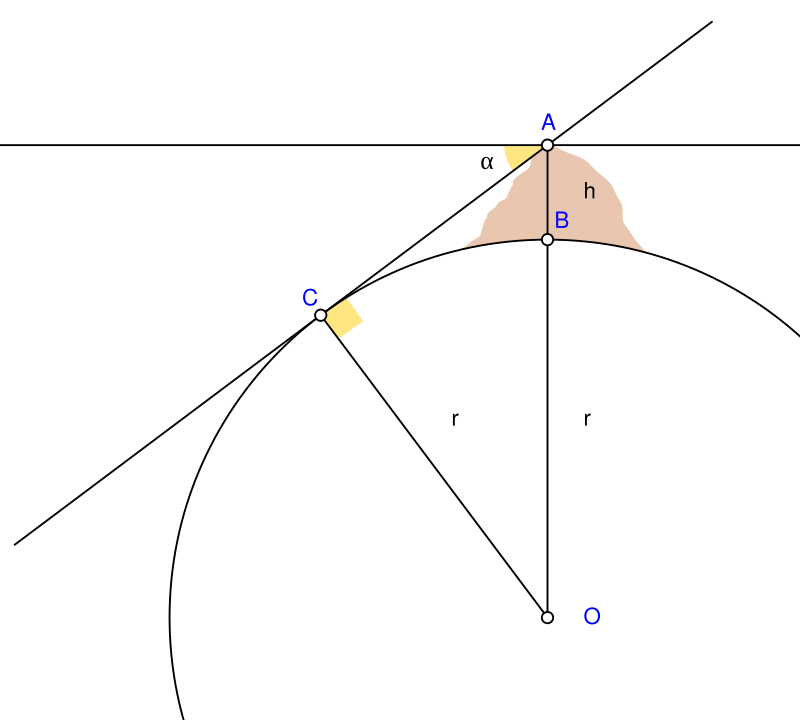
Al Beruni concluded that the method of finding, by trigonometrical calculation, the circumference or other dimensions of Earth by observing the dip of the horizon from the peak of a mountain was a fresh contribution by Beruni. He applied this method for the first time in his Nandana Experiment during 4 11-4 14 A.H.
He ascertained the sight line (extending) from the mountain peak (and) touching where the earth and the blue sky met (the horizon). The line so visualized from (my) standing position (on the peak) dipped against the (horizontally) fixed line by (an angle of) o° 34′. T h en I measured the (peak to bottom) perpendicular height of the mountain and found it to be 652-3-58751 zirac (cubits), reckoned by the z^âc used as a cloth measure at that place (Nandana). Now angle T is a right angle, angle K equal to (the angle of) the dip (° 34′), and angle H as its complementary = 89° 26′.
So if the angles of the triangle H T K are known, its sides will also be known by the proportion of T K and sines lotus ( = 1). By this proportion, T K will be 590 59′ 49″ while the excess between it and sinus lotus is o° o 11″. But that is the perpendicular height HL which is known in zirac, and the ratio of its (HL) zirac to the zirac of L K is the same as the ratio of o° o’ 11″ to 590 55″.
Reference: Al Beruni’s Nandana experiment by N A Baloch
Also read: A Noble Laureate’s Noble Gesture for His Teacher

Saadeqa Khan is the founder, CEO, & Editor-in-Chief of Scientia Pakistan. She’s a member of the Oxford Climate Journalism Network (Second Cohort) and NASW. Saadeqa is a fellow of NPF Washington, The Falling Walls Foundation, and the Science Journalism Forum. Saadeqa has won several international journalism grants and awards for her reports.
