
Bastian Werner, a German photographer, has recorded multiple events of ice halos around the sun since December 2023. This image features Ice Halos over Bavaria (APOD: 2023 Dec 20), a 22-degree halo, a 46-degree halo, the heliac arc, and other arcs. It was selected as NASA’s Astronomy Picture of the Day (APOD), highlighting the beauty of atmospheric optics.
Rare climatic effects arise when conditions take an extreme form. Examples include Morning Glory Clouds, ice halos, light pillars, derechos, haboobs, and similar phenomena. These effects signify the intricate dynamics of Earth’s climatic system and its sensitivity to natural and anthropogenic impacts.
This article aims to highlight rare climatic effects that are not commonly discussed but have a significant impact on the environment. It seeks to provide insights into these phenomena, which are not well known to the general public, and to raise awareness about the severity of these climatic issues.
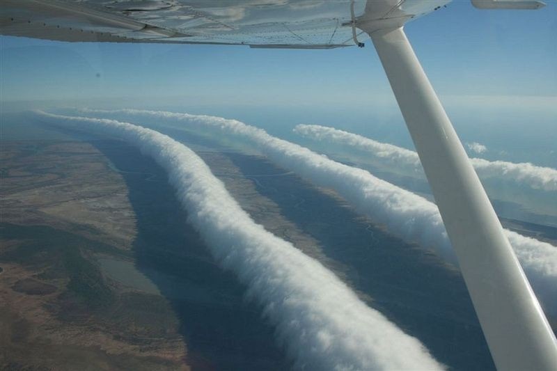
Morning Glory Clouds
Morning Glory clouds are a rare yet captivating atmospheric event in which long, cylindrical cloud formations spread hundreds of kilometers across the sky. They appear in the early hours of the day, from September to November, in northern Australia near the Gulf of Carpentaria.
Meteorological conditions associated with their appearance include the interaction of sea breezes, atmospheric overturns, humidity levels, and strong horizontal rolling motions. Their scenic beauty fascinates pilots and gliders, and the rolling airflow creates notable lift for them. Morning Glory clouds provide a unique and dramatic spectacle, illustrating the complex interplay of weather and geography.
Morning Glory clouds have limited climatic effects as they are localized. They indirectly affect weather patterns by forming roll vortices, which influence local wind patterns. Wind shifts impact aviation. The mixing of cool, moist, warm, and dry air layers causes temperature inversions, thereby impacting local thermal conditions.
The clouds trap moisture, causing changes in humidity in the lower atmosphere for a short period. Morning Glory clouds also provide insight into the development of storms. In addition to Morning Glory clouds, Morning Glory cloud tubes, Morning Glory clouds over the oceans, and Morning Glory cloud waves pose surfing challenges to gliders.
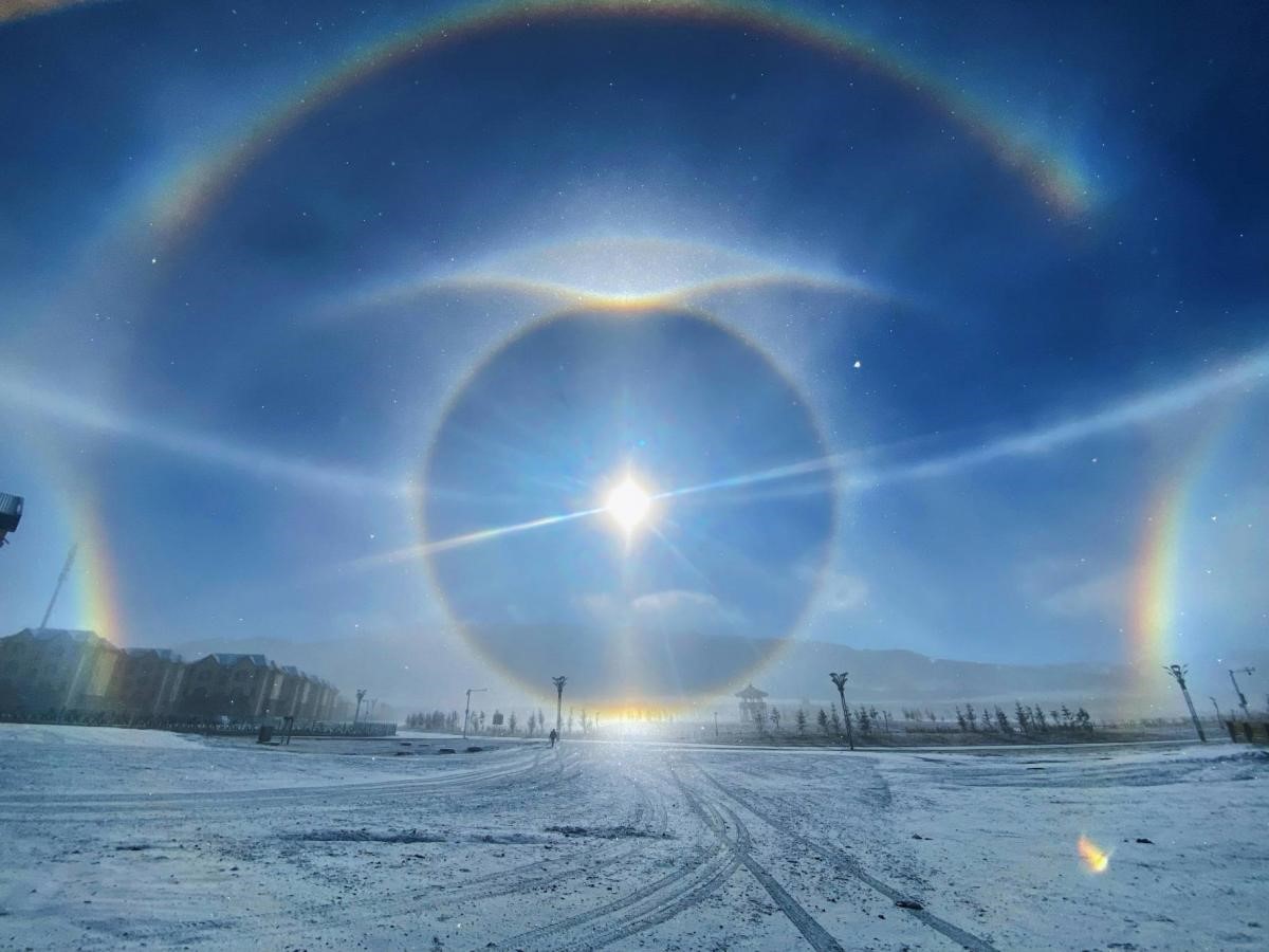
Ice Halos
Ice halos are optical phenomena created by the interaction of sunlight or moonlight with ice crystals in the atmosphere. These beautiful exhibitions occur when light is scattered by hexagonal ice crystals in cirrus or cirrostratus clouds present in the upper levels of the troposphere (5–10 km). The appearance of ice halos depends on the orientation and shape of the crystals.
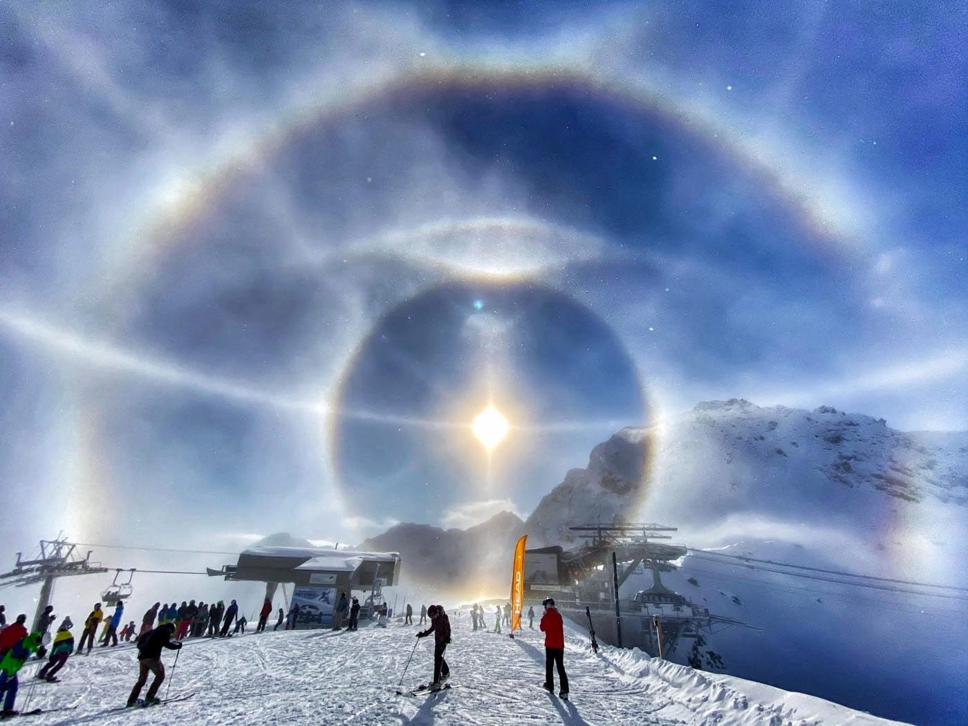
Common types of ice halos include the 22-degree halo, parhelia (sundogs), circumzenithal arc, and pillars of light. Ice halos are often observed in colder climates, but their appearance can occur anywhere depending on atmospheric conditions.
Ice halos are observed when cirrus or cirrostratus clouds contain ice crystals, indicating moisture at high levels in the atmosphere. Therefore, they indirectly suggest the likelihood of rain or snow in the coming days. The formation of halos often leads to clearer skies as they suppress storm development and prevent convection. In polar regions, ice halos are common, creating dramatic optical effects and influencing the intensity of solar light reaching the Earth’s surface.
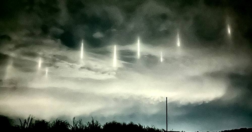
Light Pillars
Light pillars are optical phenomena exhibited as vertical columns extending either upward or downward from a light source. They are often seen at night and are caused by the reflection of light from ice crystals, similar to ice halos. The difference is that their formation can result from both natural and artificial light sources. The light is reflected toward the observer, creating a glowing vertical column.
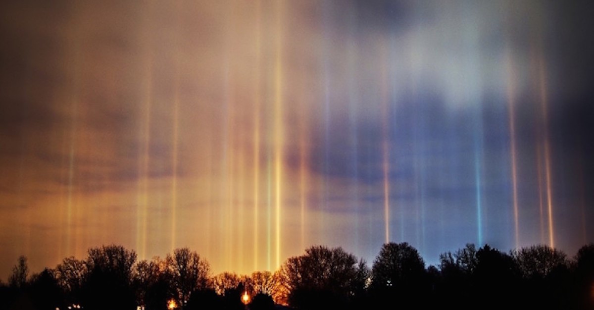
They are commonly observed in colder climates where ice crystals are abundant. They are most noticeable during winter when the air is cold enough to sustain ice crystals and clear enough to allow the passage of light. The intensity of the color of a light pillar depends on the light source and atmospheric conditions. The brightness of the color fades as it moves farther from the light source. The range of colors observed includes white, red, blue, and orange.
Light pillars indirectly contribute to our understanding of the atmosphere. Their formation requires the presence of ice crystals in the atmosphere, so observing light pillars indicates their presence. Light pillars occur during clear and cold weather, making their observation an indicator of stable atmospheric conditions.
Derechos
Derechos are extensive, lasting windstorms linked with fast bands of intense thunderstorms. The intensity of the winds can extend up to 390–640 km, often covering areas hundreds of kilometers wide. Derechos occur in the central and eastern United States, as well as in Europe, South America, and Asia.
They are witnessed in warm and moist environments and are aggravated by a cold front. Unstable factors in the atmosphere create a “bow echo” from thunderstorms, which is a salient feature of Derechos. Progressive derechos are more common in the summer, while serial derechos are observed in colder seasons.
Derechos cause damage in a couple of ways. They uproot trees, destroy buildings, and alter power lines. They are dangerous for outdoor activities and for people living in mobile homes.
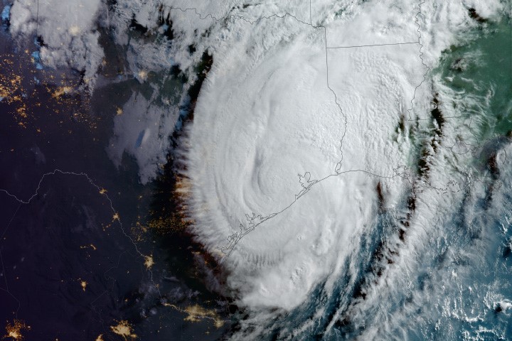
A derecho followed by a tornado outbreak was recorded between 1st and 3rd April 2024, affecting the Midwestern and Southeastern United States. On 16th May 2024, a severe derecho struck the Gulf Coast, causing damage in the Houston metropolitan area. Between 15th and 16th July 2024, a derecho moved from Iowa through Indiana, with wind speeds reaching up to 75 mph and producing several tornadoes across the Midwest.
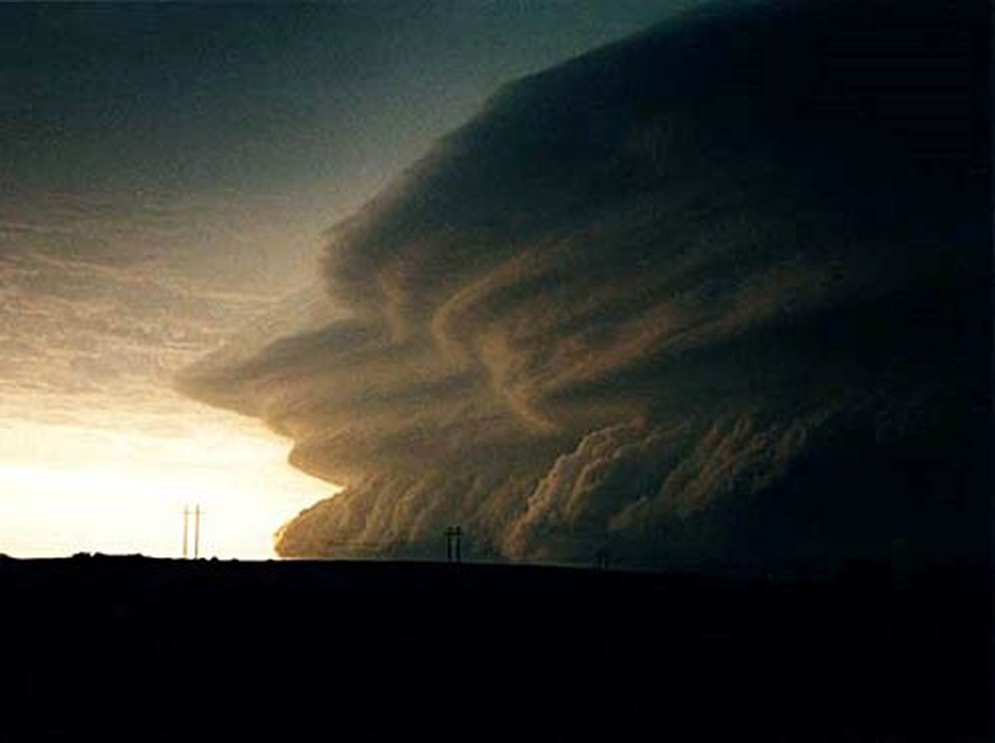
Haboobs
Haboobs are severe sandstorms observed in arid or semi-arid regions due to strong winds from thunderstorms. The term “haboob” is derived from the Arabic word “habb,” which means “blow.” It was first used to describe these storms in the Sahara Desert and the Middle East. Their occurrence is also witnessed in desert regions of North Africa and the Arabian Peninsula. Evidence has been gathered from the southwestern United States and Arizona during the North American monsoon season.
Haboobs form due to downdrafts hitting the ground and spreading outward on all sides. The wind lifts sand particles in the form of rolling clouds, and the thunderstorm appears as a towering wall of dust, rising thousands of feet and stretching for miles. Visibility drops to zero during a haboob, posing a danger to travelers. They are commonly formed during dry months.
Some of the concerns linked to haboobs are that dust inhalation can lead to respiratory issues. They can cause visibility loss to hazardous levels, leading to accidents. Haboobs also contribute to soil erosion and the transportation of nutrients and pollutants over extended distances.
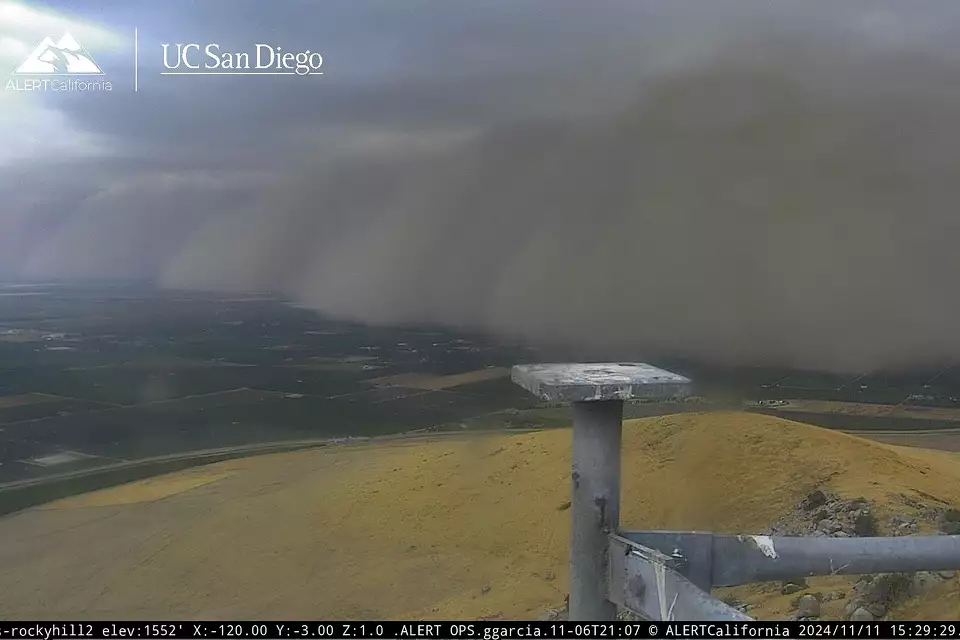
In 2024, several notable haboobs were recorded across different regions, including Central California on 11th November, New Mexico, and West Texas (exact dates unspecified), and Arizona on 24th April. The San Joaquin Valley in Central California was struck by a thick dust storm, creating an alarming situation across the landscapes of Fresno, Kings, Madera, and Tulare counties. The visibility dropped to zero, and the haboob was referred to as a “wall of dust,” rarely recorded, with a height of more than one thousand feet.
These rare climatic effects provide a picture of the complexity of the Earth’s atmosphere. Other such effects include Mammatus clouds, steam devils, ball lightning, fog bows, cloud bows, glories, Undular bore, Kelvin-Helmholtz clouds, sea smog, maelstroms, oceanic vortices, sea sparkle, icebergs with rainbow colors, sea foam, oceanic cloud bows, sea fogbows, mirages, ice discs, waterspouts, and moonbows, to name a few.
Understanding these climatic impacts as a whole can help monitor and prepare for what can be avoided and can better protect all communities.
References:
- Wikipedia contributors. (2024, December 14). Effects of climate change. Wikipedia. https://en.wikipedia.org/wiki/Effects_of_climate_change#cite_note-:0-1
- Wikipedia contributors. (2024, April 5). Morning Glory cloud. Wikipedia. https://en.wikipedia.org/wiki/Morning_Glory_cloud
- Wikipedia contributors. (2024, October 23). Halo (optical phenomenon). Wikipedia. https://en.wikipedia.org/wiki/Halo_(optical_phenomenon)
- Wikipedia contributors. (2024, June 3). Light pillar. Wikipedia. https://en.wikipedia.org/wiki/Light_pillar
- Wikipedia contributors. (2024, December 11). Derecho. Wikipedia. https://en.wikipedia.org/wiki/Derecho
- Wikipedia contributors. (2024, October 23). Haboob. Wikipedia. https://en.wikipedia.org/wiki/Haboob
More from the Author: How to connect Doraemon with real life? A science fiction series with imaginative powers for the future

Syeda Khair-ul-Bariyah has been associated with teaching since 2007. She is a synthetic organic chemist and a science and fiction writer. She has publications in both national and international journals in the field of Chemistry. Moreover, she is the author of a stage playbook, “Peregrination of the Soul,” and has a couple of articles and poems published on various websites.
