Marine biology studies marine life based on scientific research and facts. It is a very vast field since a large number of living organisms on Earth live underwater. Marine biology is interlinked with other science fields like astronomy, biological oceanography, cellular biology, chemistry, ecology, geology, physical oceanography, and zoology. It helps to study the behaviors and interactions of these living entities. It is not limited to studying living organisms ranging from tiny insects to giant animals. Still, it also covers their habitats and the benefits they give to the environment and human beings.
Since lack of resources to fulfill the everyday needs of the masses is becoming a significant issue, especially in developing countries, the utilization of marine life and its rich habitat full of minerals and other valuable materials could prove to be a sigh of relief for the millions of people around the world. From providing food and medicines to enhancing nature’s beauty, marine life contributes in numerous ways to aid benefits to the environment. We will discuss some of the essential applications of marine biology in this article.
SOURCE OF KNOWLEDGE
It is an excellent source of knowledge, as evident from many research fields related to marine biology. Biomedical researchers develop and test the efficacy of drugs, many of which are obtained from marine life. Environmental biology and toxicology are other essential research fields that directly impact our society as they check water quality and look for contamination in the marine environment.
Advancements in technology have helped marine biologists devise new instruments and formulate new techniques for collecting water samples and temperature information. Marine biologists have obtained information about aquatic organisms and their habitats with the help of underwater cameras, advanced diving equipment, television, and submarines. Jacques Rougerie, a French architect, has designed a $48 million underwater laboratory to help marine biologists observe and study organisms while living underwater.
Food, water, medicines, and shelter are some of the most essential and basic needs fulfilled by marine life.
SOURCE OF BASIC NEEDS OF SOCIETY
Although the population on Earth is increasing daily, the amount of resources available on Earth is insufficient to cater to their needs. That is where marine life has contributed so much to this ecosystem. Food, water, medicines, and shelter are some of the most essential and basic needs fulfilled by marine life.
Approximately 70% of the protein we consume comes from marine life. It is also the primary source of Omega-3 fatty acid, which is highly effective against various chronic diseases. Technological advancements and research related to marine biology have made it possible to utilize the marine environment to produce multiple compounds used in preservatives, pigments, stabilizers, food ingredients, and dietary supplements.
SOURCE OF TOURISM
According to United Nations World Tourism Organization, the number of international tourist trips worldwide reached 1.3 billion in 2017, and is predicted to reach 1.8 billion by 2030. The World Travel Tourism Council suggests that the marine tourism industry will create 400 million jobs and contribute 25% of worldwide job creation. Although it can bring economic prosperity to the lives of everyone involved, it can also harm the infrastructure. Therefore, proper planning is required to balance the positive and negative effects of tourism on the community.
The business sector may significantly promote ocean and sea protection through tourism, which may be one of the best strategies available. Hotels can support programs to inform visitors about marine life and species, including dolphins, whales, and coral reefs, and sponsor campaigns to increase awareness about maritime vulnerabilities.
The business sector may significantly promote ocean and sea protection through tourism
REGULATION OF EARTH CLIMATE
Marine organisms significantly regulate the Earth’s climate by contributing to the oxygen cycle and absorbing carbon dioxide. According to marine biologists, about 50% – 70% of the total oxygen on Earth comes from the ocean, produced by plants, algae, and some bacteria. Prochlorococcus, the smallest and most abundant photosynthetic organism on Earth, has up to 20% of the oxygen in our entire biosphere.
As the Earth warms, more carbon dioxide is released into the atmosphere. The sea is the most significant atmospheric absorber of carbon dioxide. Its ability to absorb carbon dioxide exceeds that of all forests combined.
PROTECTION OF SHORELINE
Large underwater structures known as coral reefs are responsible for the protection of shorelines from storms and waves. According to reports, about three times as much waste is thrown into oceans as the weight of fishes caught, destroying coral reefs and ultimately killing many underwater organisms.
Coastal communities depend heavily on coral reefs for shoreline protection as climate change intensifies storm strength and increases the likelihood of floods. Coral reefs act as a natural flood barrier by limiting wave energy by 97% due to their rigid structures. Continuous research is being carried out by marine biologists to spread awareness and protect the shores from the hazardous effects of industrial and other environmental pollutants.
MEDICAL IMPORTANCE
Coral reefs are very similar to human bone in their anatomical features; that is why they have been utilized in bone grafting, assuring neat and clean healing of bones. Echinoderms and other invertebrates are being used in research on regenerating multiple organs. Sponges and other organisms produce chemicals, which are used to manufacture several pharmaceutical products.
Seaweed is used to treat cough, asthma, goiter, stomach, and urinary diseases and reduce ulcers and headaches. Omega-3 fatty acid, found in abundant amounts in seawater, contributes to hormone regulation, blood clotting, genetic function, etc. Pseudopterosins, a compound obtained from Sea whip, are used as an anti-inflammatory and analgesic agent, reducing swelling and skin irritation.
Quite against the contrary, the giant shark found in the oceans is not a full-time predator. It’s called a Whale shark and is happy to feed on filters and tiny fish like krill, devouring photosynthetic algae along the way.
The question of whether this sort of green food is sufficient for the Whale shark or whether it’s just an appetizer has scientists perplexed.
Researchers at the University of Tasmania scrutinized these large sharks’ excretions to find that the sharks were consuming krill. Still, much of it wasn’t being used for the benefit of their body. Whale sharks were obtaining a lot of nutrients from algae instead.
Finding abundant arachidonic acid in the skin tissue matched the high quantities of this fatty acid in the floating microalgae Sargassam in the oceans.
In Australia’s Institute of Marine Science, experts claimed to have proved that these sharks were omnivorous rather than pure carnivorous by fatty acid profile analysis of tissues. Finding abundant arachidonic acid in the skin tissue matched the high quantities of this fatty acid in the floating microalgae Sargassam in the oceans.
Later studies demonstrated that whale sharks ate several species of microfungi and plants that construct the food chain’s base. Other sharks like bonnetheads also have a taste for plants and algae and are found to eat seagrass. They inevitably gobble it up while catching small animals for prey like crabs, mollusks, and fish and have adapted to digest it.
Scientists seem to think a similar scenario also o happened with the whale sharks. Upon hunting the animals that live on algae, they have been chucking a lot of algae, adapted to digest it, and using the nutrients for their sustainability.
There is a disadvantage to feasting on everything that comes your way, though. Some plastics were also observed in the fecal matter of these sharks. These microplastics pollute ocean currents and are ingested by the sharks and the microflora, causing their metabolism to decrease and become dysfunctional. Whale sharks are already endangered animals, and their population has declined by an astounding 62 percent in the previous 75 years.
According to a surprising observation, giant land animals have always been herbivorous, like camels and elephants. It’s no different in the underwater world; these sharks are about six to ten meters long, but they still prefer a ‘little salad’ for a vegetarian touch along with their meat.
Over the years, science has brought about many innovations in the pharmaceutical industry. The discovery of new drugs has not just improved the life quality, but also extended the life span. About 50 percent of the drugs marketed are manufactured with the help of natural products, either by directly extracting them from natural sources or utilizing them as starting materials or templates.
However, new therapeutic agents are continuously required for treating diseases like neurodegenerative diseases, inflammatory diseases, fungal and viral infections, and different types of cancers for which no effective therapies have yet been discovered.
Moreover, the diseases like malaria and tuberculosis have also somehow become resistant to most of the drugs available already. The pathogenic organisms have developed resistance to the available antibiotics. Meanwhile, the antitumor cells have also developed resistance to the cancer cells and thus require the production of new drugs from new sources.
The marine environment that covers about 70 percent of our earth’s atmosphere comprises the representatives of almost every phylum. A minimal number of these species have been studied and isolated. The ocean consists of many unexploited resources such as marine microbes, animals, and plants that can utilize for novel chemical discoveries that have the potential to be used as pharmaceuticals.
The marine environment comprises more unexplored biodiversity than terrestrial habitats, which is why it has become a hot topic. Utilizing marine resources as pharmaceuticals were introduced into the scientific world by the pioneering research carried out by Bergmann in the 1950s, which resulted in the discovery of two drugs that are marine derives, and are also clinically available today.
These drugs were isolated from the shallow water marine sponge nucleoside and are available as anticancer drugs (Ara-C) for treating acute myelocytic leukemia and non-Hodgkin’s lymphoma. The other drug is an antiviral (Ara-A) for treating herpes infections.
CURRENT STATUS OF THE DISCOVERY AND DEVELOPMENT OF MARINE PHARMACEUTICALS
The richness in species of the ocean and its extraordinary diversity with a large temperature and pressure tolerance window, presence of a variety of chemicals and metals, saline nature, low to bright light, and allopathic defenses have attracted the pharmaceutical industries to the ocean, despite the small number of compounds isolated from it to date. Marine sources are believed to have treasurable therapeutic potential based on the unique dwelling inhabitant; hence, the ocean is being explored for its hidden potential.
Throughout five millennia of discovery, diverse spectrums of marine organisms, either prokaryotic or eukaryotic, have yielded over 30,000 metabolites. Carroll et al., 2021). It’s noteworthy that the products derived from the ocean are incredibly potent and act through multiple molecular pathways, and collectively can target different ailments.
Pharmaceutical and marine sciences have joined forces to conduct extensive research and development of marine medicine. Currently, many worldwide health organizations have clinically approved fifteen drugs of aquatic origin. They prevent or manage several prevalent medical maladies, including pain, cardiovascular disease, cancer, and viral illnesses (Wu et al., 2022).
“The Global Marine Pharmaceuticals Pipeline” analyses pharmaceuticals derived from marine sources and gives summaries of both approved and pending medications”.
CLASSIFICATION OF MARINE-DERIVED DRUGS. Photo Samra Hayat
Anti-caner drugs
The discovery of the nucleosides thymidine and uridine from the Caribbean sponge Tethya crypta brought about a paradigm shift in marine anticancer medication development. Antibody-drug conjugates are vital medicines generated from marine pharmaceuticals that are relatively new. All of them, including polatuzumab vedotin (PolivyTM), brentuximab vedotin (Adcetris®), enfortumab vedotin (PADCEVTM), and belantamab mafodotin (BlenrepTM), are authorized to treat various types of cancer. The marine tunicate Aplidium Albicans also embraces plitidepsin (Aplidin®), a cyclic depsipeptide anticancer medication.
According to preliminary research, three novel cerebrosides and cholesterol sulfate from the sea cucumber Holothuria spinifera show tremendous promise as novel cytotoxic therapeutic agents (Abdelhameed et al., 2020).
Antiviral drugs
Initial research on sponge nucleosides as prospective pharmaceuticals resulted in the discovery of vidarabine for managing acute keratoconjunctivitis and recurrent epithelial keratitis caused by herpes simplex types 1 and 2. However, its license was canceled in the United States by June 2001 due to its restricted therapeutic window.
Even so, The antiviral activity of a wide range of natural compounds derived from aquatic ecosystems is still being studied. Recently, Polyphosphate (polyP) produced from sponges and marine microbes, in particular, has been found to protect against COVID-19.
In fact, according to Lee and colleagues, throughout the previous 30 decades of studies, about half of the pharmacologically functional marine compounds have been linked back to sponges (Lee, et al., 2020).
Analgesic drugs
Ziconotide may be used as an alternative to opiates in managing pain. It’s a peptide from poison found in the deadly marine cone snail Conus magus. Clinical trials have demonstrated ziconotide’s efficacy against malignant and non-cancerous pain. It does not create dependency or cardiogenic shock as opiates do.
Cardioprotective drugs
Polyunsaturated fatty acids (PUFAs) have been shown to protect cognitive functions as people age and to reduce blood-circulatory diseases such as thromboembolism and coronary artery disease. Ethyl esters of PUFAs (eicosapentaenoic acid and docosahexaenoic acid) are authorized cardioprotective medicines made by esterifying natural fatty acids in fish oil.
Neuroprotective drugs
Pharmaceutical researchers now use the active chemicals obtained in conjunction with the immediate usage of polymers created by diverse marine species to produce more specialized medications than the parent component. Sodium oligomannate (GV-971), an oligosaccharide extracted from seaweed, has received its first approval as a therapy for Alzheimer’s in China. It is a significant example of a molecular-designed drug using marine chemicals (Syed, 2020).
CONCLUSION
Recent advances in the discovery, approval and medical application of marine natural chemicals demonstrate significant promise. Significant interdisciplinary collaboration will be required between biologists, chemists, biotechnologists, pharmacists, doctors, and others, as well as between institutions, hospitals, and businesses, to address various challenges and effectively utilize marine life’s potential for drug development in the future.
REFERENCES
Abdelhameed, R. F., Eltamany, E. E., Hal, D. M., Ibrahim, A. K., AboulMagd, A. M., Al-Warhi, T., … & Abdelmohsen, U. R. (2020). New cytotoxic cerebrosides from the red sea cucumber Holothuria spinifera are supported by in-silico studies. Marine drugs, 18(8), 405.
Wu, A. C., Jelielek, K. K., Le, H. Q., Butt, M., Newman, D. J., Glaser, K. B., … & Mayer, A. M. (2022). The 2021 Marine Pharmacology and Pharmaceuticals Pipeline. The FASEB Journal, 36.
Lee, Yeon-Ju, Yeonwoo Cho, and Huynh Nguyen Khanh Tran. “Secondary metabolites from the marine sponges of the genus Petrosia: A literature review of 43 years of research.” Marine Drugs 19, no. 3 (2021): 122.
Papon, N., Copp, B. R., & Courdavault, V. (2022). Marine drugs: Biology, pipelines, current and future prospects for production. Biotechnology Advances, 54, 107871.
Pakistan has diversified its natural capital from a long coast to the world’s second-highest mountain peak (K2). The 990 kilometers long coastline shared by the coastal provinces of Sindh and Balochistan leads to the maritime zones of Pakistan. The vital sea turtle nesting beaches along the Pakistan coast include Sandspit and Hawksbay beaches near Karachi, Ormara-Taq Beach, Astola Island, and 17 Daran beaches along the Makran coast. These beaches are nesting sites of sea turtles that lay their eggs on these beaches from July to December.
Saadeqa Khan, Chief Editor Scientia Pakistan, spoke to Dr. M Shoaib Kiani, a senior professor at the Institute of Marine Sciences Karachi University, about the issues the coastal belt of Sindh and Balochistan are facing.
Saadeqa: Let us know the scope of marine biology in Pakistan and the research on marine life,especially Turtles?
Dr. Kiani: Marine Biology and Marine Science as subjects are being taught at Karachi University (i.e., Institute of Marine Science and Centre of Excellence in Marine Biology) and the Lasbela University of Agriculture Water and Marine Science. These universities run different degree programs B. Sc. (Hons.), BS, M.Sc., M.Phil. and Ph.D. programs. Additionally, various national and international level conferences, symposia, training sessions, and seminars are organized from time to time.
Over the years, these institutions have done a pretty good job in producing human resources to work in Marine Science and allied fields. However, the fact cannot be negated that not all graduates of these institutions get proper jobs in relevant GOs and NGOs. Perhaps the most striking reasons for this include a lack of proactive approach by the management of these institutions in sourcing job opportunities and linkages with job providers, lack of proper training, and absence of career counseling services.
Others include the in-built and long-standing issues of most of our educational institutions. Many of these problems are related to the shortage of human resources and proper funding. These institutions must be led by able and merit-based leadership with progress and an extension-oriented visionary approach.
Promoting Marine Science and allied fields and transforming courses and teaching methodologies to streamline with modern trends is necessary. The current scenario of the rapid degradation of marine resources and declining biodiversity demands more problem-solving research and collaborative and large-scale studies.
Part two of your first question pertains to research on marine turtles in these institutions. But first, I would like to stress the uniqueness of aquatic turtles as animals and their very long evolutionary history. Marine turtles have been present on the face of our planet ever since the presence of dinosaurs in the Jurassic period, i.e., since 201 Million Years ago. If we look into the fact that dinosaurs became extinct a very long time ago, these turtles continue till today, with very little change in their structure.
Promoting Marine Science and allied fields and transforming courses and teaching methodologies to streamline with modern trends is necessary.
This makes their evolutionary history quite remarkable and outstanding. But we should remember that although marine turtles remained resilient during drastic changes on earth throughout their existence, they remained resilient.
In today’s age of man’s domination over other life forms (called Anthropocene) and many man-made catastrophes, all species of marine turtles find it extremely hard to cope. As a result, all seven species of marine turtles have been declared “Endangered” by the International Union for Conservation of Nature (IUCN).
These turtles face an uncertain future and multiple challenges, especially habitat degradation. Their habitats are being affected by human activity quite rapidly. Moreover, some common conservation issues include illegal wildlife trade, accidental entanglements in fishing gear, pollution, poaching, using several body parts in medicines, and stealing their eggs from their nests before hatching. This species has a survival rate of only one percent. But of every hundred hatchlings, only one reaches adulthood. The rest either serve as food for natural predators or fall prey to various human activities.
Regarding research on marine turtles, the Department of Zoology, the University of Karachi, in collaboration with the Sindh Wildlife Department (SWD) and World Wildlife Fund (WWF-P), has conducted pioneering and classical studies on turtle nesting performance, hatchlings recovery, and ex-situ transfer for controlled release into the ocean. Dr. Fehmeeda Firdous conducted the study as part of her Ph.D. She has started some astonishing findings in her Ph.D. thesis, which provide beneficial insights into these amazing creatures’ lives and serve as a guide for future research.
Saadeqa: What affective part is Wildlife Pakistan playing in such marine science research projects?
Dr. Kiani: WWF-P has done a lot of work in the coastal areas of Karachi like Hawks Bay and Sandspit turtle nesting beach, specifically on safeguarding turtle nests, control of poaching and natural predators, e.g., feral dogs, recovery of hatchlings and their safe release into the sea. Meanwhile, a few studies on marine turtles have been conducted by the Center of Excellence in Marine Biology, University of Karachi. Currently, a bunch of students of mine at the Institute of Marine Science and I are working on two projects on marine turtles.
One is regarding research on turtles’ illegal trade, which a B.Sc. Hons level research project and another one is on the prevalence of microplastics in Hawkes Bay turtle nesting beach sediments. Both projects came up with intriguing findings emphasizing regular and more focused studies on marine turtles.
We found that microplastics are abundant and have the capacity for more heat, thus possibly raising the temperature of turtle nesting beaches. A few studies showed that it affected the sex ratio of eggs, and more females were born. Hence sex ratio is disturbed in such temperatures.
“Microplastics are abundant and have the capacity for more heat, thus possibly raising the temperature of turtle nesting beaches.”
Another worth mentioning research effort on marine turtles in Pakistan is by WWF-Pakistan, in which they put satellite tags on some green turtles to study their whereabouts, home range, associated behavior, and conservation issues some years back. This is an example of the use of modern, sophisticated technology in marine research in Pakistan. I am firmly in favor of initiating more such studies so that we get to know more about their lives.
Another effort by the Ministry of Environment’s Pakistan Wetlands Programme (PWP), which began in 2005, is also on record. Under this project, research was conducted in Karachi and Balochistan (Daran Beach) coastal areas on turtle nesting and its performance. They have published their work, which can search online.
In the coming years, we want to considerably increase our understanding of marine turtles, which can only be accomplished if we raise the scope of our studies to par with international research. Marine turtles feature in our priority species for the next five years, and we will try to tackle a lack of good scientific data for their optimal conservation and management.
Saadeqa: What should Government and academic institutions do to raise awareness of marine sciences among fishers and the general public?
Dr. Kiani: To raise awareness on marine ecosystems in the general public, scientists and professionals need to highlight those aspects of marine science which are attractive to familiar people, like flagship species, and can stimulate them to ponder upon their current status and issues, and need for their conservation. One surprising fact is that we people in Pakistan have never appreciated the sea and the coastal areas. We always regard the sea as mind-boggling and have never tried to study and understand it. Our communities, specifically in inland areas, have mere awareness of the sea and marine science and its concepts.
I teach students of B.Sc. Hons and M.Sc. level. These students mainly come from the coastal areas of Karachi and the other regions of Pakistan. Still, during their early 3 to 4 semesters, the only question they have for us is regarding the scope of their degree in Marine Science. This is surprising because if we look worldwide right now, Marine Science is deemed one of the most popular and charismatic fields.
The thing is, we don’t have a proper channelization mechanism for our Marine science graduates. We have taken the ocean for granted and don’t optimally use its resources. We neither explore the blessings it contains nor think about the sustainable development of its resources.
Over here, no fish of the sea is commercially grown. If we haven’t been able to do such an essential thing, it speaks volumes of our inaction and apathy towards our ocean. Our neighboring countries are ahead of us in this field, for example, Iran, India, Bangladesh, Sri Lanka, the Maldives, etc. We need to think about priorities for our institutions. Do we want to become degree-awarding institutes, or do we want skillful graduates? Can they achieve remarkable Marine Science goals and run big marine ventures, industries, and projects worth international recognition? A lot of close attention and supervision are required.
Saadeqa: What do you think, with increasing activities in the Marine Science department at KU and Lasbela University of Marine Sciences, can we motivate our youth for research in this field?
Dr. Kiani: Our institutions celebrate events throughout the year, like World Ocean Day, Turtle’s Day, Whale Shark’s Day, World Maritime Day, etc. All these and other similar ones like Seafarer’s Day see arrangements of workshops, seminars, symposiums, and pieces of training, etc. Many of these events inspire and motivate our students. Despite this, I would say that our universities (KU and LUOMS) should join hands with provinces to develop their marine science sector in the right direction.
We need to introduce courses of applied nature which should help us to solve our common problems, and from which our country’s produce from the oceans is improved. In this way, our exports can be significantly enhanced.
Previously, in the 80s and 90s, Pakistan had significant achievements. So we should work in this direction and prioritize these things. We should understand that as long as our economy does not diversify, we and our country cannot escape this crisis. If we only concentrate on agriculture and fill our plates with that, it is impossible in today’s age of science and technology to flourish. We should adopt and take such steps in every field to progress, develop institutes, and train our people in skills. I think our institutes are still not performing optimally. We need a good vision and comprehensive dialogue regarding priorities for the upcoming years. A clear example is the CPEC project. All we need is integrity, dedication, and professionalism.
Saadeqa: What is the role of the wildlife departments, whether provincial or at the district level, especially regarding the green sea turtles?
Dr. Kiani: I have highlighted in previous questions that the marine sciences institutes have faced many in-built problems; still, our departments have a few extraordinary achievements to their credit, which are remarkable and worth acknowledging. Like, I highlighted the Sindh Wildlife Department, which has banned the killing and trade of all turtles. Under the Wildlife Protection Act, it is a crime to kill them. From time to time, different amendments are made in these Acts to protect any new endangered species highlighted by the International Union for Conservation of Nature.
“Sindh Wildlife Department has banned the killing and trade of all turtles.”
Otherworld conservation organizations also exist that highlight these species and increase their level of protection. I would especially like to mention some endangered species like whale sharks, dolphins, whales, etc., that have recently received protective status. These additions are near approval by our assemblies and will be brought into action and enforcement soon. Balochistan Wildlife Department is doing precisely similar work and participating in these activities with great enthusiasm.
One thing which I much feel as a wildlife conservationist, working for the last fifteen years, is that our government institutes are a little bit more complacent and work while staying a bit reserved due to their limitations. If they have appropriate policies and five-year plans for their priorities, they can protect our country’s endangered species and biodiversity very efficiently. We can safeguard them for our future generations; secondly, they are an essential integral part of the habitat and ecosystem of our country.
And if we can establish ecotourism after proper research, it can also become a source of livelihood for our people. For example, people come to turtle-nesting beaches to watch turtles. And if they follow proper protocols and don’t disturb the turtles in any way, they can see turtles laying eggs in their natural habitat. This will meet their wish of seeing turtles living naturally in their wild habitat. It is crucial to work on proper guidelines and sustainable use of the wildlife so that future generations can take pride in their forefathers who left a good legacy for them to follow.
Saadeqa: What are the primary reasons behind the increasing death toll of Olive Turtles on the shores of Karachi and Balochistan coastal line?
Dr. Kiani: The accidental entanglements and deaths are rapidly increasing in our ocean despite the Wildlife Protection Act. Somehow, the implementation of this Act is lagging, and we cannot protect these turtles. So, here again, the reason is that the laws we make require a parallel process of scientific research and data collection and the data needed upon which we base our laws.
We need to keep collecting such data. Regarding this, we have done ground-breaking work with the coordination of Karachi University, WWF Pakistan, and some international organizations which funded us in 2011 and 2012. Indo- Pacific Fund for cetacean Research and Conservation by the Australian government and areas beyond national jurisdiction (ABNJ) projects and other small grants. Other than this, WWF-Pakistan, KU, and other leading institutes like Marine Fisheries Department cooperated with us, and we launched a project related to tuna gillnetters in the sea, which use fishing nets of the length of 2.5 km or above.
Occasionally, nets as long as 15 km also come across. These are regarded as “walls of death” in the ocean. All animals stuck in them, especially air breathers, can get entangled to death. In such entanglements, especially turtles that we mentioned before, seabirds, dolphins, whales, and mega-large fauna, including sharks, whales, etc., are all worth mentioning.
A shocking finding in the previous 4 to 5 years in this project is that, on the beaches of Pakistan, from the decade 1990 to 2000, turtles that came for egg-laying included green turtles and olive turtles.
But then, in the late 1990s, the olive turtles suddenly vanished and were not spotted nesting at beaches at all. They weren’t laying eggs anywhere either. Compared to this, the green turtles are still spotted on our shores in large numbers. Hawkes Beach (Karachi coast) is famous for nesting green turtles and features among the most significant beaches in the world for green turtle nesting.
The sudden disappearance of the Olive turtles posed a huge question mark as it was beyond our understanding. But we sent our observers on big Tuna fishing vessels and trained the captains of those ships and the crew to collect data for us. We gave them cameras, gadgets like Global Positioning System (GPS), and particular protocol forms to fill out for us. We learned that, even now, in the ocean, the olive turtle is present in a considerable number. Perhaps these turtle has disliked our beaches and is also not laying eggs there.
There was a time when we counted 28000 plus turtles of mixed species in our nets. And the boats that I am mentioning are tuna fishing vessels. About 700 big and small ships work in Pakistan’s Exclusive Economic Zone (EEZ). So we got to know that the turtles are there in such a considerable number.
Saadeqa: Besides sea Turtles, what are the major threats to other marine species?
Dr. Kiani: Thousands of dolphins were counted to die each year in Tuna fishing gillnets. This was extrapolated from the figures obtained from observers onboard tuna fishing vessels. In analytical science, “to extrapolate” means that we forecast further with the help of our sample data. We learned that nearly 12000 dolphins and 28000 turtles are dying annually. This was an eye-opener and quite shocking to hear. We worked on gear modification with our fishers and told them to use the eco-friendly gear. Unintended wildlife should not get stuck in the net and die.
An example is attaching pingers that create sounds heard by dolphins/turtles beforehand, and they become alert and do not come near the fishing net. Similarly, a turtle Excluder device (TED) is used in shrimp trawl nets. It is like a small door for the escape of turtles stuck in shrimp trawl nets.
We also devised a little technique for modifying the fishing methods to reduce dolphin mortality in tuna gill netting by our own experience. If fishers attach a weight with fishing gears, they submerge about 2m deep in water instead of remaining on the surface; thus, the mortality rate decreases.
This method was tested in some boats, and after achieving promising results, many boats were approached to adopt this new modification in tuna gillnetting. As a result, the figures for the next season showed less than 100 dolphins, and low 10s of turtles died due to entanglement in tuna gillnets.
It was a significant success, and it earned immense appreciation and acknowledgment on the international level. Much literature is available on the Internet, especially on the Indian Ocean Tuna Commission website. You will find reports of dolphins and sharks in Pakistan over there.
Oceans are reservoirs that influence climatic shifts when engaged in a perpetual cycle of moisture, heat, and carbon exchange with the atmosphere. From shaping the regional weather patterns up to global climate, oceans are the hub of climatic variations.
The vicious cycle of biological and physical processes within oceans determines the patterns of slowly changing global climate patterns. Three prime factors that drive the ocean’s impact on global climate:
Its ability to absorb solar radiation.
The large water capacity of water slowly releases the absorbed heat back into the atmosphere.
The released heat drives the atmospheric cycle, including the formation of cloud cover, the rainfall patterns and the removal of carbon dioxide from land/atmosphere.
We will magnify the crux of the process that propels the climatic variations. Atmosphere, inform of winds, and oceans, inform of ocean currents, play a role in this system. The warm winds from the equatorial planes travel towards the ice-covered poles. These warm winds direct the movement of warm ocean currents to the same destination. Due to high water capacity, the heat from the ocean water is released rather slowly into the atmosphere.
During heat loss to the environment, the water temperature decreases. Cool water tends to sink towards the bottom of the oceans while warm reaching the surface. The entire motion of ocean currents described above is known as the Global Ocean Conveyer Belt. This phenomenon makes the ocean the thermal memory of the climate system.
The biological entity underwater traps a significant amount of carbon dioxide from the atmosphere. It acts as both the source and sink of carbon dioxide production, influencing the carbon dioxide concentrations in atmospheric surroundings. The ocean’s temperature regulates the level of carbon dioxide being released or absorbed into the water. Cold water dissolves more carbon dioxide than warm water. Phytoplankton and plants consume carbon dioxide to produce carbohydrates and nutrients, respectively.
Over millions of years, a small amount of carbon dioxide becomes part of underwater reserves such as oil. The ocean conveyer belt aids in trapping carbon dioxide for years in the deeper cool ocean waters. Once the water is warmed up by solar radiation, the warm water dissipates carbon dioxide back into the atmosphere. Thus, the ocean and land are in a cycle of subsequent release and absorption of carbon dioxide.
Global Ocean Conveyer Belt
The global ocean conveyer belt system is what keeps the planet warm. Water absorbs and retains solar energy and releases it into the atmosphere via evaporation. The evaporation causes an increase in the temperature and humidity of the air surrounding the oceans resulting in rain and storms that are then carried by trade winds.
Global Ocean Conveyer Belt
Oceans transport precipitation and warm winds from tropical regions to poles and cool water from poles back to equatorial pains in a continuous cycle. Thus, ocean currents aid in heat and moisture distribution across the globe. The effect of the ocean conveyer belt can be seen in the phases of El Nina and La Nina.
El Nino (warmer phase) and La Nina (more relaxed phase) are two phases of a much larger phenomenon, the El Niño-Southern Oscillation (ENSO) cycle. The complex weather patterns affect the precipitation, upwelling of nutrients within oceans, trade winds, and events of floods and droughts worldwide. This further affects the economy of the countries involved, their social relief, and food availability. The table below shows some significant differences between these two phases of ENSO.
The aftermath of the El Nina and La Nina phases is significant. ENSO in southern Asia contributes to approximately 10%-20% aberration in world GDP. ENSO negatively affects South Asian Indian monsoons as during the given period, the subcontinent experience less monsoon rainfall. South Asian countries (Pakistan, Bangladesh, India) are primarily agricultural-driven economic countries. The unpredictability of timings, amount, and areas of heavy monsoon precipitation can devastate water supplies, crop growth, food availability, and employment rates, especially in rural areas.
ENSO events indicate a potential menace to Pakistan’s economy. Weak monsoon trade winds over the Bay of Bengal result in less monsoon rainfall in Pakistan. A decrease in precipitation is a potent threat to water availability leading to drought conditions in Pakistan. Moreover, La Nina phases bring along high rainfall, which might affect the quality of wheat crops, especially for the 2021 financial year. Lack of snowfall in northern regions means less melted water towards low-lying areas, a nuisance for crop irrigation. The conditions can worsen if the wheat crop production falls short of the demand, ultimately causing escalated prices and inflation.
Pakistan experiences an overall shortage of water during the ENSO cycle. La Nina brings along more than average rainfall; however, dams’ lack of storage capacity (Tarbela, Mangla) leads to little to no water storage. The excess water due to precipitation becomes a cause of floods in low-lying areas. El Nina cycles result in less rainfall, meaning water scarcity for irrigation. To compensate for this, water is directed from dams (primarily used for electricity production) which depletes the large water reserves present within the country.
Global climate and ocean currents also affect the local daily weather (precipitation/storms). Though this relation between cause and effect is mainly unclear, recent studies concluded that changes in ocean currents of the Atlantic Ocean are attributed to variation in rainfall in Western Hemisphere.
The adverse effects of ENSO cycles on Pakistan will continue to linger as a threat to Pakistan’s economy if appropriate measures are not taken. The Metrological Department of Pakistan should consider these changing weather patterns as a grave emergency and monitor the weather patterns. A pivotal step will be passing the weather-related information to farmers so that they can take necessary precautions timely.
“The greatest danger to our planet is the belief that someone else will save it”- Robert Swan
Frida stood rooted to her spot, fascinated by the vast stretch of calm deep water lying peacefully in front of her. As she observed the royal-blue waves gently crashing into each other, she felt her weariness and troubles ebb away, and a soothing peace washed over her. The ocean’s surface was dotted with gold from the setting sun, and as she lingered further on the deck of her ship, she wondered what the mysterious massive ocean held beneath its layers of cobalt, sapphire, and navy.
She’d watched a documentary recently about the technologies and scientific methods usedto make discoveries about the ocean. The physical features of water, chemical composition, and the variety of life thriving underneath those waves were all described in detail in that documentary.
Then they discussed the machines and complicated methods to study all these. Her mind had grasped very little of the science involved because she was a literature major herself. Nonetheless, she still enjoyed the ocean even if she didn’t understand it. The mere fact that it was complicated and mysterious had a unique charm.
So many people like Frida are unaware that a whole branch of science focuses on studying oceans and their depths from many perspectives. Let’s see below which of these facts are new and which are somewhat familiar from watching movies or reading fiction.
The ocean is home to a wide range of life, including fish, sea animals, plants, fungi, and other microorganisms.
Oceanography
The field that explores the wonders of the oceans in detail is quite exciting and, at times, dazzling. Writers and poets often use the beauty and depth of the sea to indicate the depth of human feelings. There is no doubt that these massive water bodies continue to mystify us despite a whole branch of science delving into them. Oceanography deals with the scientific study of oceans’ biological, chemical, and physical aspects, including their geography, paleontology, ecology, chemistry, etc.
The main branches of Oceanography or oceanology include:
Oceans are also studied from a chemical perspective to find out the reactions that occur within them, their related conditions and effects on the water, the chemical composition of the coral reef, ocean bed, etc., and the impact of chemical pollution on the ocean.
The biological side of oceanography contemplates the living organisms of the ocean and their interaction with each other and their environment. The ocean is home to a wide range of life, including fish, sea animals, plants, fungi, and other microorganisms.
Physical oceanography explores the physical properties and processes of the ocean like waves, currents, tides, atmosphere, sand, etc. It is an essential subfield because we can better understand the motion and action of oceans and predict their future.
Geology in this field investigates the landscape of the oceans in detail, like underwater mountains, trenches, etc., and helps map-making and predict earthquakes with the help of the tectonic plates’ theory. Another sub-branch worth interest is paleontology, which studies the fossils in the ocean bed to etch out a history of the life and events of maritime history.
Remember that all these fields are interconnected; for example, when studying ecosystems, we need to know the physical aspects, temperature, etc., best suited for life. When we discover a new fossil or shell, analysis of its chemical composition may make our research more fruitful.
Why study the ocean?
One cannot imagine the critical role of oceans in sustaining life on this planet. Many readers here would think, ‘hey, humans are land-dwellers. What have we got to do with the ocean?’
Here are some facts that highlight the significance of oceans in our lives:
The ocean produces more than fifty percent of the oxygen and stores fifty times more carbon dioxide than our atmosphere.
The air we breathe
The ocean produces more than fifty percent of the oxygen and stores fifty times more carbon dioxide than our atmosphere.
Climate regulation
Oceans cover 70 percent of the Earth’s surface. They play a role in transporting heat from the equator to the poles and regulate weather and climate patterns.
Food and Medicine
Besides fish and seafood, many other substances are extracted from the ocean, which are valuable ingredients for other foods like peanut butter or soymilk. Ten percent of human protein intake comes from the oceans. Many of these biochemicals in the sea serve as effective drugs in treating diseases like Alzheimer’s, cancer, and cardiovascular disease. Marine pharmacology explores the potential of chemicals from sea animals and plants to treat illness.
Transportation
The oceans connect different continents of the Earth and serve as a passageway to trade and connection via ships.
Recreation
several water sports like fishing, boating, kayaking, and whale watching provide unique entertainment and an opportunity to enlighten ourselves with information about the ocean.
Economy
The ocean economy annually helps to earn billions. It not only strengthens the economy’s backbone with tourism, food and pharmaceuticals, and other valuable resources but also solves the increasing unemployment problem. Products of the ocean that have commercial value include pearls from oysters used in the jewelry industry and coral used in building materials and construction.
Marine Biology explores the living organisms thriving in the ocean, their ecosystem, their interactions with each other, and the environment.
Linking Oceanography with Marine Biology
So, oceanography involves the study of the oceans from not only a biological but chemical, physical, geographical, and archeological perspective. On the other hand, marine biology comes under bio-oceanography. It explores the living organisms thriving in the ocean, their ecosystem, their interactions with each other and the environment, and aspects like marine nutrition.
Ten Technologies to Understand the Mysteries of the Ocean
High-frequency radar (HFR) is a unique technology for mapping ocean surface current and wave fields (along with other variables) over broad areas with high spatial and temporal resolution.
Sea gliders make oceanographic measurements traditionally collected by research vessels or moored instruments. They can move around or be fixed at one spot and can be commanded to alter their sampling strategies throughout a mission.
Marine telemetry implies attaching devices to animals to gather data. These telemetry devices, called tags, are fixed onto various marine species, from tiny salmon smolts to giant 150-ton whales. Tags are attached to the outside of an animal with clips, straps, or glue and are sometimes surgically inserted into an animal’s body. Research vessels, buoys, and satellites receive signals from the tags.
Telemetry tags describe the animal’s movements and can also pick up information about the animal (temperature, heart rate, oxygen levels).
Telemetry tags describe the animal’s movements, and they can also pick up information about the animal (temperature, heart rate, oxygen levels), its behavior (vocalizations, breathing, tail beats), and its environment (sound, temperature, salinity, light).
These studies considerably enhance our perception of animals’ locations and how they answer to climate change and human-made disturbances. Telemetry data also helps to keep a count of the population so that we can figure out if the species is endangered or not. Marine telemetry is relatively cheaper than other technologies and can be used in areas that are difficult to study, such as the Arctic.
A drifter is an oceanographic device floating on the surface to investigate ocean currents and other parameters like temperature or salinity. Modern drifters are typically tracked by satellite, often GPS.
Drifters provide real-time information about ocean circulation. They make more accurate and frequent surface current velocity observations than possible from remote sensing measurements. Drifters are frequently used to collect data on biological oceanography, such as the transport of organisms.
Intelligent Buoy System (INBUS) was developed by the Korea Institute of Ocean Science and Technology (KIOST). Depending on the type of probes attached, the buoys may collect data on temperature (in the air, at the surface, and depth), wave height, wind speed, and direction, as well as current speed and direction. Fixed buoys can read the weather, detect tsunamis, and monitor tides.
Like the microphone collects sound in the air, a hydrophone detects acoustic signals under the water. Most hydrophones are based on a particular property of certain ceramics that produces a small electrical current when subjected to changes in underwater pressure. When submerged in the ocean, a ceramic hydrophone produces small-voltage signals over a wide range of frequencies as it is exposed to underwater sounds emanating from any direction. Hydrophones accurately measure ocean sounds by amplifying and recording these electrical signals.
Clod cards are a simple way of measuring relative water flow using blocks of plaster of Paris. As water flows over the obstructions, they dissolve. The faster the flow, the more they dissolve, a process called dissolution. Who would’ve thought such simple techniques could also help oceanography?
Sonar is a technique that uses sound propagation to navigate, measure distances, and communicate with or detect objects on or under the surface of the water, such as other vessels.
Sonar, short for Sound Navigation and Ranging, helps explore and map the ocean because sound waves travel farther in the water than radar and light waves. Scientists primarily use sonar to develop marine charts, locate underwater hazards to navigation, search for and map objects on the seafloor such as shipwrecks, and map the seafloor itself.
This technique is especially implied in studying the geography and archeology of the oceans.
“ROV” stands for a remotely operated vehicle; ROVs are unoccupied, highly maneuverable underwater machines that can use to explore ocean depths while operated by someone at the water surface.
ROVs are primarily used when humans diving is unreasonable or hazardous, such as working in deep water or investigating submerged threats. ROVs and AUVs carry equipment like video cameras, lights, and robotic arms to grab things. Where humans can’t go, these underwater robots help us safely study the ocean.
Satellites can observe the oceans in so many unique ways because of their altitude. They can easily cover all the oceans of the planet. Some of the dimensions of physical oceanography studied are sea surface temperatures, water circulation patterns, sea surface colors and locations of algal bloom, sea level changes and weather, tracking, and mapping. The satellites for sea color are called SeaWiFS.
Newer Technologies in Oceanography
Acoustic Doppler Current Profiler
An acoustic Doppler current profiler (ADCP) is a hydroacoustic current meter to evaluate ocean current velocities over a depth range using the Doppler effect of sound waves dispersed back from particles within the water column.
By interpreting the acoustic signals, this device calculates the ocean’s depth and the current. This device is used for rivers to measure the total flow of the current. It is beneficial for underwater vessels on marine expeditions to predict the ocean penetration and navigate the vessel.
ADCPs are also helpful in measuring wave dimensions like wave height, wave direction, and turbulence. The two critical rewards of ADCPs are the lack of moving parts that need biofouling and remote sensing, where a single, stationary instrument can measure the current profile over ranges exceeding 1000 m. These highlights permit long-time measurements of the ocean currents over a considerable segment of the water column.
CTD (Conductivity, Temperature, depth)
A CTD or sonde is an oceanography device to determine seawater’s electrical conductivity, temperature, and pressure. Depth is directly related to pressure, while conductivity is used to determine salinity. It is reliable because it gives highly resolved data.
Radioactive dating and environmental DNA
These techniques are purely biological and imply the hunt for fossils and DNA analysis. Coral reefs can be found with the help of carbon dating, the age of corals and shells. This tells us about the ocean bed’s history and aquatic life.
Environmental DNA refers to the extractable DNA collected by sending a volume of seawater through a filter with minor porosity. Many organisms, plants, and Micro life shed cells, fragments, and particles and excrete metabolic waste products into the water surrounding them. Analyzing the DNA in the cells could help us better understand marine life’s processes.
Magnetometer
A magnetometer is a passive instrument that measures changes in the Earth’s magnetic field. Ocean exploration can be used to survey cultural heritage sites such as ship and aircraft wrecks and characterize the seafloor’s geological features.
Under the sea, marine geophysicists, ocean engineers, and nautical archeologists use marine magnetometers to distinguish differences in the total magnetic field of the seafloor. Usually, the increased magnetization is caused by ferrous (unoxidized) iron on the seafloor, whether from a shipwrecked boat made of steel or a volcanic rock containing magnetite grains.
Expendable Bathythermographs
An eXpendable BathyThermograph (XBT) is a probe that is dropped from a ship and measures the temperature as it falls through the water. This torpedo-shaped device drops through the water column, sending the data back along the copper wire.
Limitations of Ocean Technology
The rapid development in oceanography is leading us to a better understanding of marine biology. However, some factors hinder our complete knowledge of the ocean. We must first be able to grasp the fact that the sea is vast and deep beyond our imagination. It’s a separate world with its archeology, hidden minerals, resources, and life forms. Humans have explored only a limited part of the oceans and are in for many more surprises.
One problem, for example, is the difficulty involved in studying the ocean bed. The pressure of the water is so high as you go deeper down that it becomes stressful to learn it with devices directly. Of course, indirect techniques like SONAR exist, but that’s all we’ve got right now.
Another problem is the cost—the fancier the technology, the more cost and maintenance it requires. Only well-off countries like the US can afford to invest in oceanography and arrange for escapades deep down the water. Developing countries like Pakistan have not yet achieved a milestone in oceanography due to the limited funds for this research.
Oceanography devices cause disturbances in everyday aquatic life and sea life behavior. This causes shifts in ecological balances and population sizes. Accidents with probes or devices could lead to species extinction or increased psychological stress in marine life.
Most of these devices have scalability issues due to noise and visual pollution in the water. These problems increase as you investigate further down the ocean.
The technology of any kind comes with a price, and it is only worth it if the technology is sustainable, reliable and accurately fulfills its purpose. There is still a need for a hefty investment and improvement in ocean technology to understand and unveil the ocean’s mysteries.
In the last few years, fish captures have not been the same in Mubarak Village, in Pakistan’s coastal Sindh province. As coral reefs have declined, so have incomes for local communities, said Asif Baloch, a fisherman from the village.
“Fishing is not a sufficient source of survival. A year ago, our daily catch was enough to take to the market at the end of the day, but now we have to wait a whole week to have a good catch for sale,” the fisherman said.
Coral bleaching in Pakistan’s coastline is among the greatest threats climate change poses to this Asian country. Massive bleaching in recent years is altering the composition of fish communities, endangering hundreds of jobs in the area.
The catch of fish in Mubarak village, for example, decreased to around 10% of what it was twenty years ago. Currently, average daily wages for fishermen hardly exceed 6 US dollars, according to Baloch.
Bleaching has also impacted tourism in the area. Massive coral degradation in the coastal provinces of Sindh and Balochistan has forced government authorities to close down some of the main attractions on Pakistan’s coasts, such as scuba diving in Churna Island, located in Balochistan.
In spite of this, both activities play a significant role in Pakistan’s economy. Fisheries generate about 1% of the country’s GDP and provide jobs to around 1% of the country’s labor force, according to a report by World Food and Agriculture Organization (FAO).
Tourism, on its part, is responsible for 2.8% of Pakistan’s GDP, but it represents an even bigger share in Balochistan. However, as coral bleaching intensifies, these activities become vulnerable.
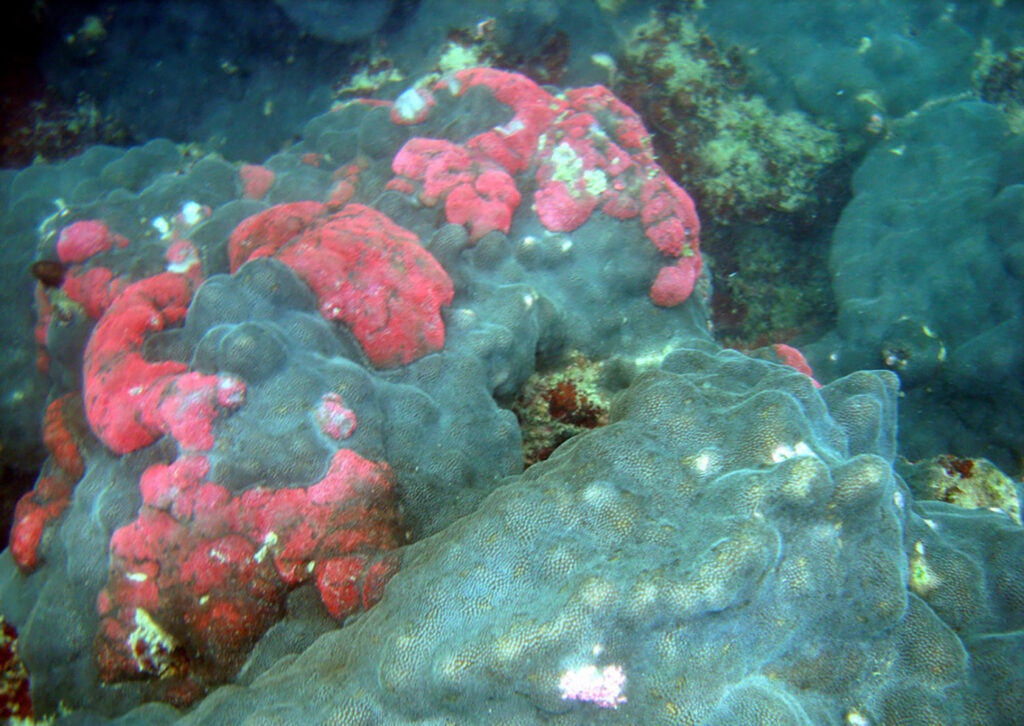
At a global level, coral reefs are some of the most threatened ecosystems due to climate change. Photo IUCN Pakistan
Corals live in a symbiotic relationship with a type of algae called Zooxanthellae, which helps them feed. Bleaching occurs when rising water temperatures force corals to expel the algae and starve. If the bleaching lasts too long, corals die.
Climate change has already increased water temperatures in the Arabian Sea, causing massive coral bleaching in Pakistan’s Balochistan province, said Moazzam Khan, marine expert with WWF Pakistan. Fish communities are some of the most affected by this.
In addition, human activities, such as fisheries and tourism, add pressure to these already stressed ecosystems. Some scientists suggest stricter protection from marine conservation areas is needed in Sidh’s coastal ecosystems to help corals recover.
At a global level, coral reefs are some of the most threatened ecosystems due to climate change. Under a 2 ̊C warming scenario, up to 90% of the world’s reefs could be degraded, under a 2013 study published in the journal Nature.
Threatened jobs
In Pakistan’s coastal areas, around 400.000 fishermen and their families are dependent on marine resources for their livelihood. When corals bleach, the whole ecosystem declines, and fewer resources end up available for fishing.
Mubarak village, locally known as Mubarak Goth, has faced some of the most serious impacts. Most of its residents go to Churna Island for fishing, where massive coral bleaching was recorded in 2020.
The village —composed of around 5.000 people— lacks proper access to basic needs for its residents, presenting problems with fresh water, electricity, schools, and health centers.
In response, locals adopted destructive approaches like trash fishing, which refers to catching very small fish with small nets. This approach prevents seeds or juvenile fish from reaching adult size and breeding.
After the government banned these illegal fishing practices, many fishermen gave up their traditional profession and started working in tourism.
But massive tourism activities caused severe damage to the already climate-stressed corals in Churna. After extensive evidence of coral degradation, the Pakistan Navy banned scuba diving in the area.
Currently, only a few certified tourism companies are allowed to function here, leaving people from local communities who started jobs in tourism without permits for tourism and without means for fisheries, Baloch said.
Bleaching has had a “devastating” effect on local communities, added Dr. Fehmida Firdous, a marine researcher at Karachi University. Along with her team, she launched awareness campaigns about the importance of corals in the localities of the Churna and Astola islands.
Like other natural ecosystems, corals can repair damage to their ecosystems independently, but it takes decades and efforts from local communities.
During this process, it is mandatory to maintain the temperature between 23-26 ̊C, a high concentration of Oxygen, and less waste material. The researcher explained that local communities could eventually manage this stable environment with education and training.
Pakistan’s impacted corals
Pakistan’s coastal line is among the many seas that have a vast coral ecosystem. Climate change and other human activities now threaten these reefs.
Back in the 1980s, Pakistan’s shorelines were thought to be unfit for the growth of corals, according to research published by UNEP. However, rich coral ecosystems were discovered in 1995 in Churna Island, with Hump, Leaf, and Star reef (Acropora) formations. Even more, they were discovered later in the rest of Balochistan.
These corals are now under stress in Astola Island and Churna Island, where the threat of extinction is prevalent. Scientists say that the primary cause of coral bleaching in Churna is the rise in Sea Surface Temperature (SST).
When sea levels rise due to climate change, corals end up on deeper water levels than where they grew. As more water covers the reefs, they start to receive less sunlight, compromising their growth.
Climate change also causes the water temperature to rise, forcing the corals to expel the algae that help them feed. This is a major driver of coral bleaching around the world.
According to Zubair Siddiqui, a senior climate scientist at Pakistan Meteorological Department (PMD), the average water temperature in Pakistan from June to October 2019 was 27 ̊C. This is a slight increase from ideal conditions since the average temperature for normal coral growth is 23-26 ̊C.
Storms also play a role in degrading corals. The observed increase in water temperature can also lead to more severe tropical storms. The sea waves in the monsoon season can break coral branches and overturn coral colonies.
In Churna and Astola islands, an additional problem is ocean acidification since their shores are surrounded by a thermal power plant, oil refinery, and a single-point mooring system for marine cargo transportation. Additionally, another coal-fired power plant in Gwadar and a Liquid Petroleum Gas (LPG) terminal near the coastline is under construction.
The seawater near the islands absorbs CO2 emissions generated by these fossil fuel activities and becomes more acidic. These acidic conditions further degrade the structures of coral reefs.
The seawater near the islands absorbs CO2 emissions generated by these fossil fuel activities and becomes more acidic. Photo IUCN Pakistan
Saving the reefs
Some initiatives have emerged to protect Pakistan’s corals in the coastal Balochistan and Sindh provinces.
The Balochistan government, for example, is working on an artificial reefs project created out of cement and rods to preserve the island’s natural environment. They are placed at several locations essential to maintaining biodiversity.
Nadeem Khan, director of fisheries Balochistan, is heading this project along with conservation organizations. He is confident that the strategy will work in reducing stress from human activities, such as fisheries, to the already climate-stressed corals.
Artificial reefs are widely used worldwide as a fishery management tool to restore habitat for marine creatures. According to Dr. Sato of Hokkaido University Japan, the fish catch in artificial reefs can be increased by 10 kg per cubic meter.
But other efforts have also been implemented to protect these ecosystems. Firdous, on her part, launched an awareness campaign in local communities, urging them to protect the corals so they can still have access to fishing resources.
With her team from Karachi University, she handed over posters and pamphlets to educate the villagers about the importance of deep-sea corals for the marine ecosystem and the illegal and misguided fishing practices that play a role in coral destruction.
The region’s provincial government should declare Churna a Marine Protected Area (MPA) immediately, Firdous recommended. This would help protect biodiversity and the future of fisheries in Pakistan
Without intervention, local communities will continue to suffer the most serious impacts of coral bleaching, said Dr. Firdous.
Culture, identity, and borders separate one country from another. They are all mere accidents of history and the products of specific circumstances- even the continents that seem so stable in their configuration and location are fickle in the eyes of the geologic time scale. Now separated across the Atlantic, there was a time when South America, India, and Australia were arm in arm, dancing around the South Pole. The evidence for this lies in the most unlikely of places.
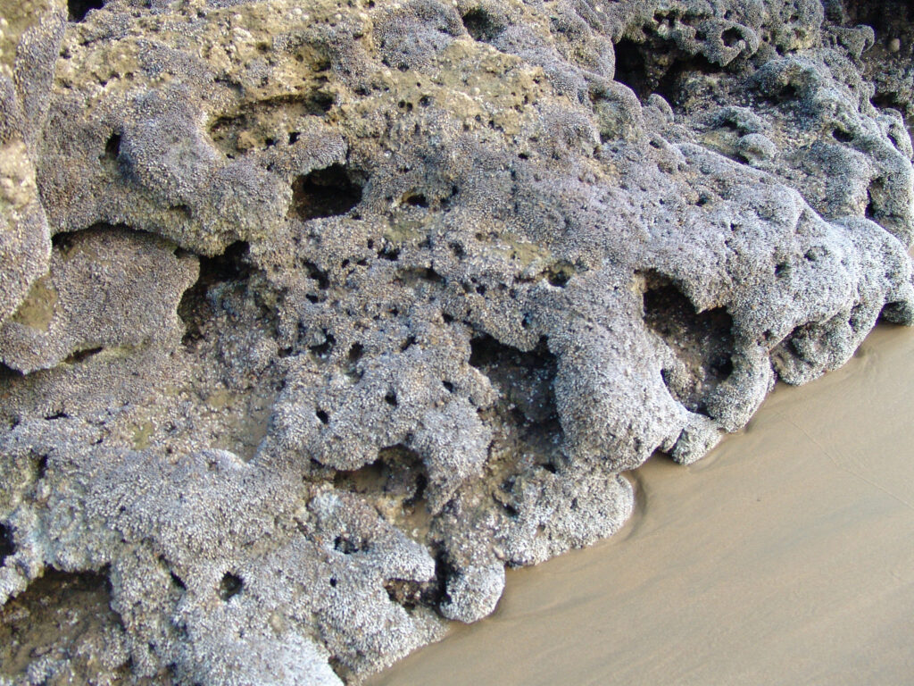
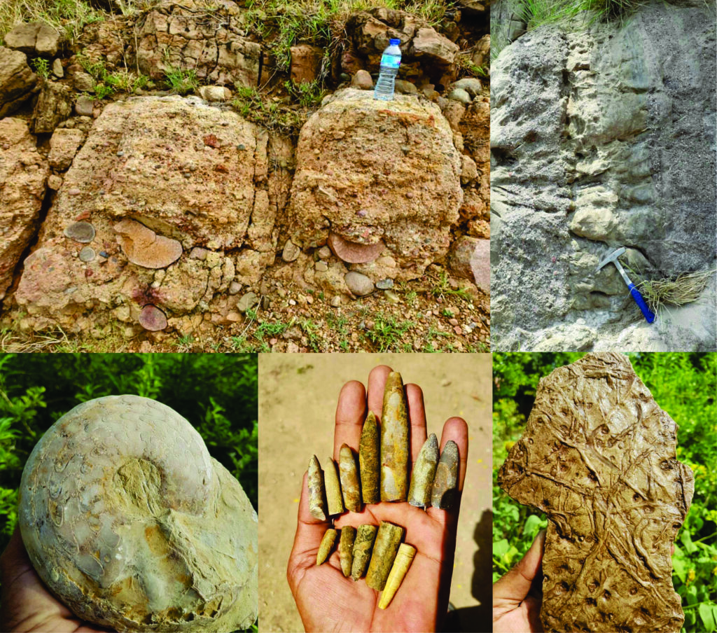
I was at the entrance point of Zaluch Gorge, in the Western Salt Range, some 15 miles north of the city of Mianwali, on the 25th of August 2021. Due to the scorching heat, I had already finished half of my water bottle before starting the traverse. As I began, right in front of me, I saw little pebbles trapped inside the rocks rather peculiarly.
They seemed to be cut with a sharp knife by a master chef. These sharp cuts, in geological terms, are known as ‘faceting’ and are a work of no other than a glacier. When a pebble is trapped at the boundary of two glacial layers, the difference in the relative movement of the layers cuts the stone sharply. These pebbles were either deposited directly when the glacier melted or in the vicinity of a glacier by a stream originating from it.
These rocks are reminiscent of times when the Indian Plate was covered with glaciers. At the same time, the streams flowed northwestwards towards the mighty Tethys Ocean, as indicated by the presence of the granite pebbles that originated from southern India and were brought to their present location by glaciers and streams.
Similar glacial sediments can be observed at many places in the Salt Range and along the Choa Saidan Shah road. Geoscientists correlate the glacial rocks of the Salt Range with Talchir Boulder Beds of India, and Al Khlata Formation of Oman and Saudi Arabia based on the presence of glacial signatures in all these rock units indicate their deposition in the proximity of the South Pole.
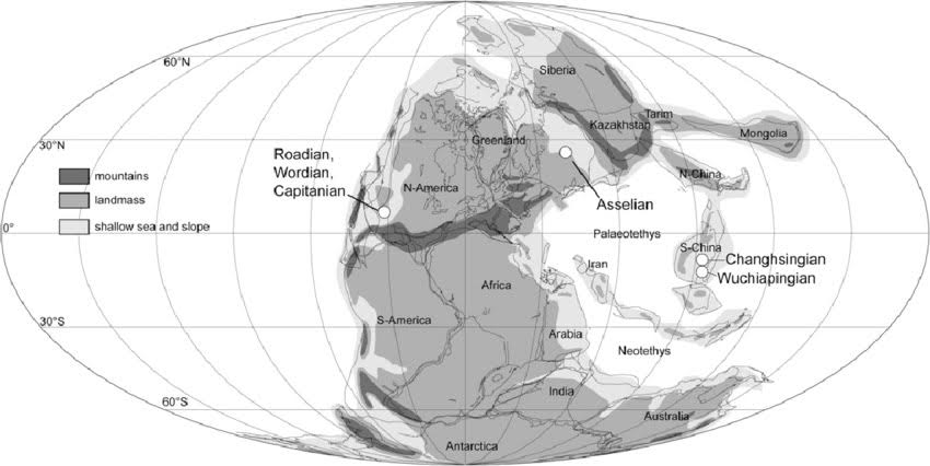
Such deposits during the Permian period (before dinosaurs appeared) have been reported from all the southern continents, which were part of the supercontinent Gondwana as it drifted slowly around the South Pole.
Map of the world during Permian time when the glacial rocks of Salt Range were deposited. Indian Plate can be seen near the South Pole (Lucas et al. 2006)
As one moves further into the gorge, it feels like traveling through time as every few meters of rock layers has condensed millions of years of Earth’s history. The world Is getting warmer, the signs of which are recorded as fluvial (river) deposits overlying the glacial ones in the form of sandstone beds of the Warcha Formation. It is a rock unit of considerable thickness and spatial extent, indicating a meandering river that emptied into the Tethys Ocean.
Soon (geologically speaking), the sea level started to rise. The earlier Warcha Formation river deposits began to be buried by the ocean sediments full of fossils, including brachiopods, bivalves, ammonites, and gastropods. This composite rock unit is called the Zaluch group, named after this very gorge, where it has the best-exposed outcrops.
For me to be holding these fantastic fossils, many factors needed to come together, e.g., an organism dying in a manner that allowed it to be fossilized, if the fossils right in front of me would have been eaten by a predator or destroyed by the wave activity. I wouldn’t be observing them here today. Most importantly, the collision of the Indian tectonic Plate with the Eurasian tectonic Plate resulted in the formation of this crack (Salt Range Thrust), along which millions of years old rocks came up and were exposed to the surface.
I collected a few fossils and went on to look for shade. At some distance, under a bit of bush, I found a shepherd resting while his sheep were jumping across the bare slopes in search of grass. I went towards him; he offered me a cup of tea, and we started chatting. During our conversation, I realized that he did not know his area’s geology and fossils.
He was somewhat concerned about his livelihood and his children’s education – questions much more essential than thinking of some long-gone organisms. I told him about the remarkable history of the rocks in his area. However, he seemed disinterested in my stories, and the discussion circled back to politics, scarcity of jobs, and the deteriorating financial situation of the region.
As a final attempt to fire his curiosity, I told him that this piece of land we are sitting on right now has traveled more around the globe than both of us and probably more than most of its inhabitants. However, this attempt was also in vain; he looked at me as if I had gone completely crazy. I thanked him for the tea and stood up to continue my journey.
With the parting greeting, however, he suggested looking at a rock at the top of the mountain. ‘There are sparrow’s beaks in the rock,’ he exclaimed. I got curious and hurried to see it for myself. At the top, many brachiopod fossils protruded from the rock, and as had accurately described, they seemed like beaks stuck in the rocks – a life frozen in time.
Earlier this year, I was reading our former prime minister Imran Khan’s book ‘Pakistan: A Personal History’ where he briefly mentioned the Salt Range and how much he enjoyed hunting there. Still, I didn’t come across his vision for promoting and preserving the area’s geological heritage.
Just at the back of Salt Range sits Namal University, one of the best institutes in Pakistan, but after discussion with some students there, I realized that they were as oblivious of the geological heritage of the area and as caught up in their problems as the shepherd I had met in the Zaluch gorge. However, two months before the Zaluch Gorge trip, I had quite the contrary experience.
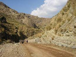
Zaluch gorge. Photo Sikandar Hayat
I went to Villuercas Ibores Jara, UNESCO Global Geopark in Extramadura, Spain, as part of my Erasmus Mundus program. It was a hot summer day when we reached a local primary school within the geopark. To my surprise, the children there were well aware and quite excited about the local geology, ecosystems, and biodiversity. On school walls, with the help of local artists, they had painted different ancient ecosystems as preserved in the rocks around the school. They were grounded, took pride in their heritage, and were aware of the changing local ecosystems.
Later on in the trip, we visited the local olive farms, wineries, livestock farms, and some small local businesses. The vineyard owner explained to us the formation of soil that resulted in land perfect for grapes. His 8-year-old daughter, who grew up at the local livestock farm, explained the groundwater flow; every single person there was so connected to their land and took ownership to protect and preserve it for future generations.
On one particular occasion, we met some school children aged 6 to 14 making little road signs indicating sites of detailed geological or biodiversity interest and how to take care of natural heritage. In a tiny town, the buildings’ walls were covered in tiles, mined from a local quarry, full of ichnofossils of trilobites (imprints of their movement).
The thing I found most astonishing was the awareness of natives about their surroundings – their history, culture, and how they incorporated all of it into tourism and their economy. Schoolchildren explained to us the local biodiversity, indigenous plants, and how the birds prefer to make their nests in local plants.
Understanding how the world has changed and will continue to change geologically, climatologically, and culturally is crucial to put ourselves in comparison to the immense expanse of time. Geoparks are vital in getting these concepts across. Talking about Pakistan’s geo-heritage, it would not be an overstatement that we have one of the best and most well-preserved geological records in the world. Still, despite the present tourism-friendly atmosphere, we haven’t developed a single UNESCO Global Geopark in Pakistan.
Salt Range, Pakistan, has recorded the history of the Indian Plate as it traveled from the South Pole, covered with glaciers, to its current location in the present day, and all the stories it saw during this time are hidden in its rocks. Not only rocks, but the temple of Katas Raj, Nanda fort near which Al-Beruni measured the circumference of the Earth, Takht-e-Babri, and even the Khewra Salt Mine shows the progress of human civilization. The changing cultural landscape for thousands of years nested in changing geological landscape for millions of years, and layers upon layers of stories hidden to be told.
Along with the Salt Range with its sedimentary rock record of pre-Cambrian to Recent, Pakistan is gifted with myriad other geological wonders, including mantle rocks exposed along Karakoram highway at various places, the Kohistan Island Arc, Cambrian Nowshehra Reef Complex just next to Nowshehra city, some of the largest glaciers, and mud volcanoes to name a few.
The geologic heritage is suffering, and we are facing the worst natural disasters, including landslides, the outburst of glacial lakes, earthquakes, floods, and seawater intrusion. Understanding their causes is essential for the public to reduce the deaths and damage caused by our ignorance.
Rocks and fossils of Salt Range (Bottle, hammer, and hand are used for scale) a) Glacial rocks of the Salt Range containing pink faceted pebbles of Nagarparker Granite (clean cut shows glacial action) (courtesy: Muhammad Faheem) b) The alternating pebbly and sandy beds show changing water energy that deposited these rocks (these beds were deposited horizontally, but the tectonic activity moved them to their present vertical position) c) Ammonite (courtesy: Muhammad Faheem) d) Belminites (there is a myth about these fossils that they are bullets used against the British army) e) Trace fossils (show the movement of ancient organisms)
On the biodiversity front, we are facing challenges, too, e.g., half of Islamabad suffers from pollen allergy during spring because of Broussonetia papyrifera (Paper Mulberry), an invasive species planted to make the city green. Today, the city is green, but many birds have left, and the residents suffer every spring. It is the need of the hour for the government to divert its focus from cashing in on the scenic mountain peaks of the North and instead prioritize the geological heritage for tourism, education, and economic development.
The information on the geology of Pakistan is not scarce, but it is somewhat trapped in scholarly journals and the geology departments of academic institutions. If given the opportunity, academia can play a massive role in bringing geological awareness to the forefront. Strong coordination among PTDC, Geological Survey of Pakistan, universities, local schools, and media can help locate, preserve, and promote our heritage.
Thinking about all the possibilities to preserve and promote the geological heritage of Pakistan, I did not realize that the sun had started to hide behind the hills. I sat on the cliff’s edge and played the ghazal ‘Waqt ki qaid mai zindi hai Magar, chand gharian Yahi Hain jo azaad hain.’ I could not stop thinking about the fantastic creatures whose fossils were peaking out of rocks in front of me and about the paleo-landscapes. It was a feeling of time and space transcending.
Nature, love, and creativity know no boundaries: I was enjoying a song written by a Pakistani poet, and sung by an Indian singer, and while listening to it, I was wondering about ancient times when this piece of land was traveling across the ocean to its
present destination. The rock strata beneath me contain the stories of so many different worlds, worlds where our species was not even in the picture, let alone the star or villain of the picture. Yet, somehow, all the stories of earlier worlds intertwined to give rise to our story. A humbling and profound realization of connectivity and belonging.
We are the first species with not just the ability to alter the planet on a geologic scale but also the mental ability to foresee the consequences. We are aware of the link between our actions and each of the Earth’s possible futures. I wish all my country fellows could feel the same and celebrate their mountains, rivers, and rocks.
After finishing the field trip, as I was coming out of the gorge, I happened to see a graveyard nearby, and, partially out of habit and curiosity, I decided to visit it. Inside, I noticed something unique about the graves there. Unlike most tombs in Pakistan were built with concrete and finished with a nice tombstone with the name and date of death of its inhabitant marked. Several graves were decorated with Permian limestone, which is full of fossils. At the same time, the monument on top was a reddish rock full of trace fossils, a reminder of the inevitability of death and the preservation of life in nature – one by us, the other by nature itself.
Homo sapiens originated from Africa over 300,000 years ago, and genetically modern humans emerged at least 195,000 years ago. History shows that the first signs of early modern humans outside Africa were found in Israel 194,000 to 177,000 years ago and in Greece 210,000 years ago. Modern human remains were recorded in East Asia 80,000 years ago. Some archeological evidence revealed that they reached Australia 65,000 years ago.
However, in Europe, their appearance seems to have occurred much later, perhaps because of ecological barriers and the region’s occupation by Neanderthals. The earliest evidence of Homo sapiens settlement in Europe was found around 45,000-43,000 years ago based on five isolated dental remains from three Italian sites and one in Bulgaria.
Together with history, anthropology, and social science, Archeology has struggled to find the answers to some crucial questions about the origin of the earliest societies and their cultures. The search was started somewhere in the 1980s; researchers have come to understand and now explain the existence of facts and attitudes in the human way of living and thinking that constituted behaviors.
With the help of new concepts and methods, anthropologists have learned about ancient civilizations’ social and cultural aspects. Meanwhile, their main quest was to explore more about the ‘otherness of others,’ a rather complicated concept in anthropology that has been the focus of several renowned anthropologists since 1980.
The earliest evidence of Homo sapiens settlement in Europe was found around 45,000-43,000 years ago based on five isolated dental remains from three Italian sites and one in Bulgaria.
An example that best explains the concept of the otherness of others is the human ego. Anthropologists have been trying to figure out the existence of cognitive ego in humans for a long. They found that the cognitive ego is different from the social ego and intimate ego in humans.
Together with history, anthropology, and social science, Archeology has struggled to find the answers to some crucial questions about the origin of the earliest societies and their cultures.
The social ego can be inherited from ancestors, but it mainly develops and grows over the course of a lifetime. However, the intimate ego is fashioned from birth by pleasant or painful encounters with others; it is also called ‘the ego of desires and sufferings.’
More often than not, anthropologists immerse themselves in another society or another milieu to better study and understand the societal norms and behavioral patterns. Their observations are based on their participation in daily life chores of the concerning cultures. This practice requires struggle, high passion, and sweat and is entirely different from going hunting with a group of people.
Realizing the significance of anthropology in the modern world, Scientia Pakistan brings its exclusive edition on Anthropology. We have got some exciting stories on the Nabatian kingdom, the cultural diversity of Pakistan, progressive political anthropology, the significance of modernization in anthropology, South Asian languages, the RNA world, and much more.
We reached out to some prominent anthropologists and chatted about the significance of anthropological studies in Pakistan.
Summing up, this edition will be fantastic entertainment for all anthropology and social science lovers.
South Asia is home to a plethora of languages ranging from approximately three hundred to well over a thousand. However, most of these languages are derivatives of each other but have different technical aspects. In South Asia, language and culture are closely associated; that is why many people claim that replacing local languages with English can cause a shift in cultural values and is therefore not promoted in some parts.
In his book, The Languages of South Asia, a Russian linguist, G.A Zograf, claims four primary language families in South Asia: Indo-Aryan, Dravidian Austro-Asiatic, and Tibeto-Burman. The first two of these constitute most of the languages spoken across this diverse world territory. They all have their own unique origins and evolutionary histories, and we will discuss each of them in detail in this article.
INDO-ARYAN
It is one of the most widely spoken language families in the World and has more than 800 million speakers. Its origin dates back to the mid-first millennium B.C, with the evolution of Sanskrit. There are further three subcategories of this family, based on their growth. Old Indo-Aryan, which constitutes Vedic and Sanskrit, developed into the Middle Indo-Aryan family comprising Prakrt, Maharashtra, Pali, etc. By the end of the first millennium B.C, the current New Indo-Aryan family gradually evolved, incorporating many of South Asia’s most widely used spoken languages.
In the Northwest, Dardic (Kashmiri, Kalasha, Kohistani, etc.), Punjabi, Sindhi, and various Pahari languages are widely spoken. Maithali, Bengali, Assamese, and Oriya are famous in the eastern part of South Asia. The major languages consist of Hindi, Urdu, Bhojpuri, Awadhi, and various Rajasthani languages. Gujarati, Maharashtri, and Sinhala in Sri Lanka are other widely used languages in this diverse family.
Sanskrit has a significant influence on this language family, as it is clear from the numerous modifications that took place during the evolutionary phase of the current modern languages. These changes follow a regular pattern, e.g., ‘hand in hasta was modified to ‘Hatha’ in Pali and then ‘hath’ in Hindi/Urdu. Similarly: ‘eye’ in aksi was modified to ‘akkhi or acchi’ in Pali and then ‘ankh’ in Hindi/Urdu. Most of the Indo-Aryan languages follow these trends except for some Dardic languages.
Maithali, Bengali, Assamese, and Oriya are famous in the eastern part of South Asia.
The Turkish and Iranian invasion of the Indian subcontinent also added a lot of new words to the vocabulary of these modern languages. Urdu, sometimes referred to as the sister language of Hindi, was heavily influenced by Turkish and Persian, as well as Arabic. Portuguese, Dutch and French also had a minor influence on the vocabulary of these languages.
In South Asia, language and culture are closely associated; that is why many people claim that replacing local languages with English can cause a shift in cultural values and is therefore not promoted in some parts.
DRAVIDIAN
It is also a popular language family spoken by more than 220 million people in South Asia and is divided into four branches. The languages spoken in the northern parts comprise Brahul in Balochistan, Malto, and Kurukh; the southern central one consists of Telugu and Gondi. The main parts have a few less famous languages like Kolami or Parji, and the southern regions have Tamil, Malayalam, Tulu, and Kannada as major languages.
Although there is little research available about Dravidian origin, it is speculated that it was first noted on the walls of caves in Madurai and Tamil Nadu. Some linguistics argues that these languages were brought to South Asia by migrations from the Iranian plateau. Researchers also claim that Dravidians were present before the arrival of the Indo-Aryans, approximately 3500 years ago, and were the most widely spoken languages in the Indian subcontinent. Connections exist between Dravidian and other language families, especially the Indo-Aryan family, and significantly influence Telugu and Malayalam.
It was Alexander D. Campbell who pointed out the presence of the Dravidian language in his book, “Grammar of the Teloogoo Language.” Robert Caldwell, in 1856 published his Comparative Grammar of the Dravidian or South Indian Family of Languages, which proved to be a significant event in the expansion and establishment of Dravidian as one of the major language families of the World.
AUSTRO-ASIATIC
Austro-Asiatic combines two Latin words for “South” and “Asia.” It is also one of the major language families in South Asia and Southeast Asia, spoken by more than 117 million speakers in various parts of the World, including Thailand, India, Bangladesh, Nepal, China, Vietnam, and Cambodia.
Austro-Asiatic combines two Latin words for “South” and “Asia.”
According to research, approximately 168 Austro-Asiatic languages are divided into three groups; Munda, Mon-Khmer, and Khasi-Khmuic. Two of these languages, i.e., Vietnamese and Khmer, are the official languages in Vietnam and Cambodia. There is no clear evidence available about its origin.
TIBETO-BURMAN
This family has more than four hundred languages spoken by 60 million people in various parts of South Asia, Southeast Asia, and East Asia. Its name stems from two of the most widely spoken language families of this group, namely Burmese, which almost 35 million people speak, and over 8 million people speak Tibetan languages.
Its origin is linked to the great Sino-Tibetan language family, subdivided into Chinese and Tibeto-Burman. This language family is further divided into various branches. The most notable are Kamarupan, spoken in Northeast India and West Myanmar, Himalayish in Tibet, Nepal, Bhutan, Jingpho-Nungish-Luish, Lolo-Burmese-Naxi, and Karenic in Thailand and Myanmar.
South Asia is one of the World’s most diverse territories, and just like other attributes, the languages spoken here are also unique in their features. These languages originated from different areas and evolved considerably with time. Even after British rule, the love and connection with these languages didn’t fade away. Considering the population growth in South Asia, it is highly expected that the popularity of these languages will only be increased in the years to come.

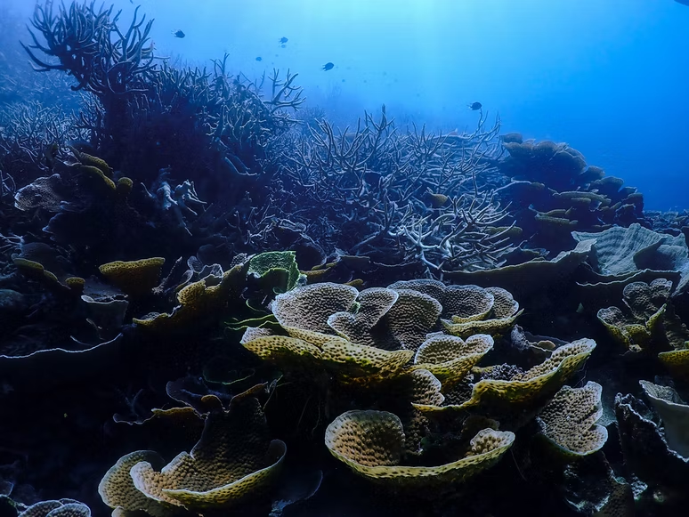
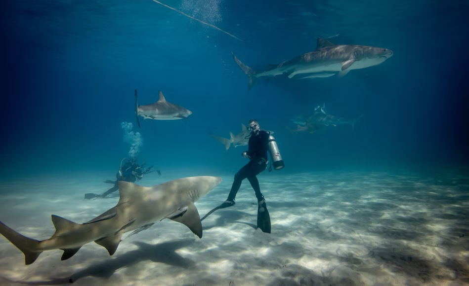


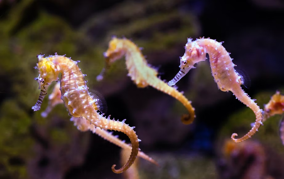
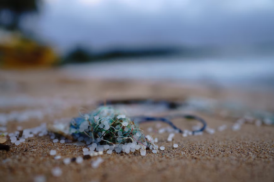
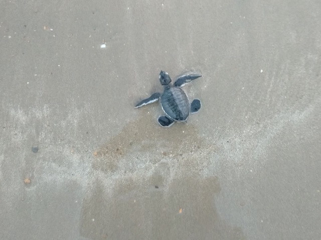

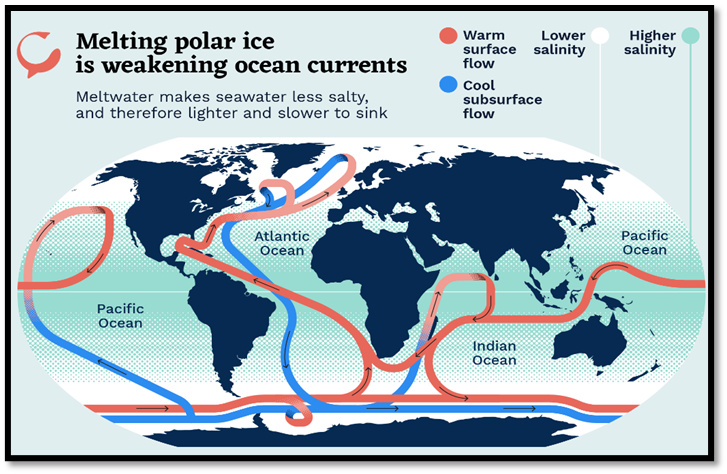
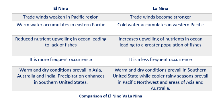

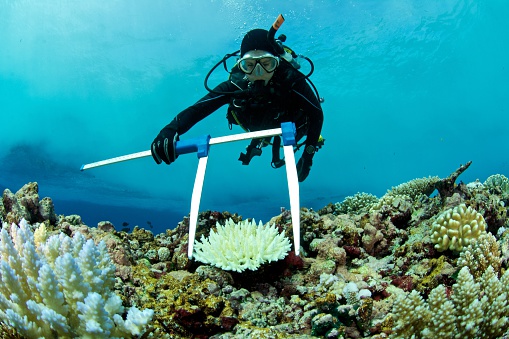
/Humpback-whale-and-calf-Cultura-getty-56a5f84e3df78cf7728ac019.jpg)