One cannot imagine the level of deviance human beings have figured to get themselves knee-deep in. Animals are part of this planet and have their own ecosystem and world in which they are immersed. Interfering in their little world and then disrupting it for them when they’ve wronged us in no way is surely a crime.
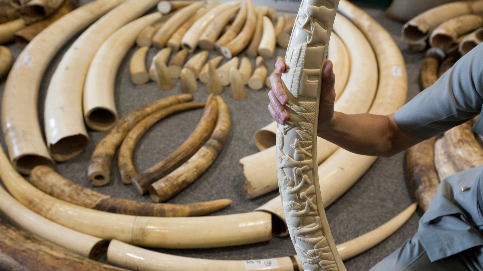
Some examples of prevailing wildlife crimes include trading and smuggling, for example, poaching elephants for ivory. Other crimes include illegal trafficking, obtaining and consuming wildlife flora and fauna e.g., timber and other forest products, against the law. Illegal hunting and fishing are also high on the list. According to wildlife crime reports, the pangolin is the most poached animal in the world.
When I heard the name of data science, the first thing that popped up in my mind was a long tabular display of numbers and statistical formulae to play around with them. I had little to no idea that this emerging science field could help investigate crimes against wildlife. Let’s dive deep into data analysis of the recent rise in wildlife crimes.
Forensic science is also known as criminalistics and is applying scientific techniques to identify criminals in investigations. Wildlife forensics involves tracking down the animals mysteriously disappearing or being smuggled etc.
Some of the common techniques used in wildlife forensics involve microscopy, PCR, and DNA sequencing. Since wildlife crimes have become global and organized threats these days, the techniques used are also technologically advanced. Talking about microscopy, samples found at crime scenes can be analyzed in detail using the different kinds of microscopic techniques now available.
Some examples of prevailing wildlife crimes include trading and smuggling, for example, poaching elephants for ivory. Credit: IFAW
We can use microscopy when dealing with crimes related to mammals because analyzing hair samples is always part of the crime scene. We can analyze the type of hair in question, and from that, we can figure out which animal the hair belongs to. For this, we need a data bank that already has the analyzed data from the hair of common mammals. Different parts of the mammal hair can be compared, like the general hair profile, the root and shaft of the hair, the outer cuticle of mammalian hair, the solid cortex or center of the hair, the inner core of the hair, or simply the cross-section of the whole hair cell. An advanced technique like scanning electron microscopy is used to capture pictures from different angles, and this pictorial data is then analyzed.
In cases where mammals are not involved, DNA analysis remains the king of all techniques. This is because DNA can be extracted from any kind of body cell and analyzed. The basic protocol followed is extracting DNA from the cell, increasing it in number by the Polymerase Chain Reaction, and then sequencing it to reveal the exact genetic code.
In forensic genetic identification, this DNA data is used first to identify animal species. This is done by analyzing the sequence similarity of genes with a certain species’ genes in the databank. Secondly, it is used to identify the geographic origin of the species. Once we know the species, we can track down where it is common. This is a key lead in our forensic case as we are now knowledgeable about the location of our wildlife crime.
Another technique used in wildlife forensics is the study of elemental profiles. This means comparing the different types of isotopes present in our sample. This is especially helpful when we need to find out if our animal was from the wild or bred in captivity. You see, the sources of food consumed in both these habitats may have different isotopes of organic elements, so elemental profiling becomes necessary.
The main method used to study isotopes is mass spectroscopy, which uses the principle of comparing the masses of different molecular compounds with relation to the possibilities of all the isotopes of the atoms present in them.
While these techniques all require special apparatus and ski much simpler ones used along with the above ones, we all know how important footprint analysis is. This takes me back to my childhood where I loved the cartoons Scooby-Doo, the dog, along with his group of human friends, was always solving ghost mysteries with a magnifying glass glued to one eye in search of clues.
In forensic genetic identification, this DNA data is used first to identify the animal’s species. This is done by analyzing the sequence similarity of genes with a certain species’ genes in the databank. Credit: CITES.org
Footprint impressions can help us track down the path of a species and identify the species as well as their age and size. But since there are so many animals in the wild, footprints of different species are often mixed up in the ground or soil, which may pose a challenge for the tracking-down team of scientists.
Serological techniques involve interaction between the sample cells and species-specific antibodies to confirm the identity of the organism the cells belong to. This is a precise and thus accurate detector, but most labs do not have antibodies for the serum of many species.
Recently, three new techniques applying the principles of radiation have been implied to the field of wildlife forensics. Firstly, we have infra-red techniques, which are basically very good at detecting organic compounds in body fluids and samples and several kinds of fibers like hair, fur, etc. This technique is advantageous over the rest because it is cheaper and highly reliable as it requires easy examination of samples like soil, food, etc.
An example of its application includes identifying the geographical roots of herbal medicines.
Another hurdle faced by wildlife investigators is the presence of metal ions in their samples. For that, a technique called Inductively coupled Plasma Atomic Emission Spectroscopy is used. The ions present in bone or other tissue samples link us to whether the animal experienced a kind of natural or man-made catastrophe like a fire or bomb blast.
Radioisotope tracer techniques are used in wildlife forensic cases as well, where carcasses, teeth, talons, tusks, feathers, or stomach contents can be analyzed to see if the animal has been exposed to any kind of radioactivity.
Although most of these techniques may sound fascinating, they are not simple to perform. Sometimes several techniques need to be done collectively, and long data analysis is required before answers can be found.
Some Limitations of Forensic Science
The biggest hurdle is not marking the crime scene and finding the evidence but, in fact, preserving and recovering the evidence. Footprints can easily be eroded or erased. Hair, teeth, claws, etc., start to decay, and decomposers start to feed on them. Species identification is only possible if there is information beforehand in the databases. Most biochemical techniques require skilled labor, maintaining machinery, and a high cost. Since wildlife forensics is not much of a focused career in developing countries where the law is still fighting for human rights, many of these techniques are still to be made available. Modern laboratories, training for forensic scientists, and collaboration with international wildlife organizations are all steps that could lead to a better future for wildlife forensics.
The term “Deepfake” was first coined when a Reddit user with the same name shared a few digitally engineered adult videos of a couple of female celebrities in 2017; he used deep learning technique for the alternation.
Deepfake, one of the novel forms of misinformation, has become a real challenge in the modern communication environment due to its rapid spread through online news and social media.
Falsehood, fantasy, fake news all have walked along with the development of modern communication and journalism. There is evidence of misinformation since the Roman Empire (Barkhart, 2017). It was later developed as a strategy with the invention of print in the 15th century. The possibility of disseminating written misguided information in a faster way made the circulation of fake news much more accessible.
One of the remarkable examples of misinformation of our time was the radio broadcast of the “War of the Worlds” directed by Oscar Welles on Oct 30, 1928. This radio show was followed by thousands of listeners, and a minority believed that our planet is under the aliens’ attack, thanks to the fabulous narration of Welles.
The misinformation has been using against enemies in conflicts and wars, as we witnessed in World War I & II, Vietnam War, and the Gulf crisis. A recent example of fake news propaganda was of China and the US against each other. After the emergence of Coronavirus from Wuhan, the irresponsible statements/ tweets of former US President Donald Trump added fuel to the fire.
There have been different proposals for classifying fake news during the last few years, like news satire, a prevalent form of fake news with a significant presence in magazines, websites, and radio or TV shows. And news parody, which shares some of the characteristics of news satire, but is not based on topical issues.
The promoters of these pieces mostly try to deceive by blending them among the truthful ones. Like the spread of Coronavirus first linked to 5G network and then claimed that it was engineered by Bill Gates. It was told to the public that they can detect the virus-germ by placing a halved onion in their rooms and vice versa. The wave of misinformation and myths was so intense that WHO introduced a new term, “infodemics”.
Danielle Citron, a Prof of law at the Boston University, says, “it appears that the deepfake technology is being weaponized against women mostly for the revenge.”
The fake news conspiracy theories/ stories trend is not new; they have always been there, but in recent years, corresponding to the rise of social media, the public’s interest in fake news has grown sharply because “Controversy sells”.
Presently, one out of five internet users gets their information via YouTube, Facebook, or Twitter. We live in a post-truth era characterized by the digital information warfare running by the media giants to manipulate public opinion for their personal interests.
Besides, photo manipulation, alteration of images, and more recently, videos are widely used to build a different reality for advertising and public relations. In Nov 2019, Hao Li, pioneer of deepfake, stated that “this trend is growing more rapidly as I was expected. Soon it’s going to get to the point where there is no way that we could actually detect deepfakes anymore, so we have to look to new technologies for the solution.”
Hao’s AI firm Deepfake found over 15,000 fake videos online in Sep 2019, nearly doubled in just nine months. A staggering 96% were pornographic, and 99% of those mapped female celebrities’ faces onto porn stars. Danielle Citron, a Prof of law at the Boston University, says, “it appears that the deepfake technology is being weaponized against women mostly for the revenge.”
The fraud through deepfake audios, voice skins, and voice clones is also trending. Last March, the Chief of the UK subsidiary of a German energy firm paid nearly 2 00,000$ into a Hungarian bank account after being phoned by a fraudster who mimicked the German CEO’s voice. Similar scams have reportedly been used in recorded WhatsApp voice messages.
How are Deepfakes created?
Hyper-realistic or deepfake videos are the product of Artificial Intelligence applications that can combine, merge, replace, and superimpose images or short video clips for creating a fake video that appears authentic. The game-changing factor of deepfakes is the scope, scale, and sophistication of the technologies involved in its creation process.
Hyper-realistic or deepfake videos are the product of Artificial Intelligence applications that can combine, merge, replace, and superimpose images.
It takes a few steps to make a face-swap video. First, runs thousands of face shots of the two people through an AI algorithm called an encoder. The encoder finds and learns similarities between the two faces and reduces them to their shared standard features, compressing the images in the process. A second AI algorithm called a decoder is then taught to recover the faces from the compressed images.
Because the faces are different, one needs to train one decoder to recover the first person’s face and another decoder to recover the second person’s face. To perform the face swap, he simply feeds encoded images into the “wrong” decoder. For example, a compressed image of person A’s face is fed into the decoder trained on person B. The decoder then reconstructs the face of person B with the expressions and orientation of face A. For a convincing video, this has to be done on every frame.
How to spot Deepfakes?
One of the biggest challenges of deepfakes is to find out how to counteract them knowing that the debunking methods’ development is always late regarding the production of misinformation. However, a great deal of effort has been made—and is still under the attempt to develop technology-based tools for detecting and correcting it, both from public and private organizations.
Researchers from the Binghamton University, State University of New York, and Intel Corp have teamed up to develop a tool, “Deepfake catcher”, which boasts an accuracy rate above 90%. This tool works by analyzing the subtle differences in skin color caused by the human heartbeat. In deepfake, there is no consistency for the heartbeat and no pulse information at all.
Another remarkable effort is the US’ Deepfake Detection Challenge (DFDC), co-partnered by AWS, Facebook, and AI’s media integrity steering committee US, to spur the researchers around the globe to build innovative technologies that can help detect manipulative media.
There are specific rules one can follow to detect a deepfake video, such as facial transformation; checking if the eye is blinking as humanly as possible (weakness which has now been fixed in new videos), watching the eyes, scanning the cheek and forehead movements, etc. told Asad Makki, senior business solution manager at SAS.
This is how a layperson can detect manipulation in online content, but high-quality deepfakes aren’t easy to discern. The only way left is to educate and stay updated about advancements, both in deepfake tactics and detection technologies. Besides, one needs to build intuition for identifying “what is real and what is fake”.
A probe sent by the United Arab Emirates to study the Martian atmosphere has caught and brought us mesmerizing images of the beautiful natural light show i.e Auroras. The views on the red planet are as beautiful as, if not more, those on Earth.
Before the formal start of the Hope orbiter’s science mission, an instrument installed on the probe caught the aurora, which is known to be a phenomenon that is very difficult to study. The images were a delight, as they were not part of the planned observations on the mission.
Images released recently show the auroras standing out in the shape of bright structures set against the dark Martian night sky.
EMUS data showing the discrete aurora on Mars. The bright crescent marks the daylit side of the planet; the discrete aurora is the bright crackles seen on the nightside of Mars. (Image credit: Emirates Mars Mission)
In a statement given to Space.com reports: a space.com, Justin Deighan, a planetary scientist at the University of Colorado and deputy science lead of the mission, said, “They’re not easy to catch, and so that’s why seeing them basically right away with [Emirates Mars Mission] was kind of exciting and unexpected.” “It’s definitely something that was on our radar, so to speak, but just looking at our first set of nighttime data and saying, ‘Hey, wait a second — is that? — it can’t be — it is!’ — that was a lot of fun.”
Aurora, the natural light display in the Earth’s sky, is predominantly seen in high-latitude regions.
The Ultraviolet Spectrometer installed on the probe was originally meant to study the massive halo of hydrogen and oxygen that surrounds the Red Planet, which eventually dissipates into open space.
“We did anticipate that the instrument would have the potential to do this,” Hessa Al Matroushi, the mission’s science lead, said in a statement. “It wasn’t designed to do it. But because we do have a mission that is targeting global coverage and we’re looking at Mars from different sides and very frequently within the atmosphere, that enabled us to have such a measurement of discrete auroras, which is very exciting.”
Technology is one of the essential driving components to economic growth at all levels. The recent advances in nanoscience and nanotechnology intend new and innovative applications in almost every aspect of life. At present, several groups around the globe are investing extensively in nanotechnology and considering it a powerful tool for the next industrial revolution. Nanotechnology harnesses the potential of the combination of physics, chemistry, material science, biotechnology, and engineering to create atomic-scale materials with a more significant number of exposed atoms on the surface.
However, the success of nanotechnology partially depends on the source/precursor of nanomaterials or support of nanomaterials in terms of availability, renewability, functional groups, contamination-free, and biodegradability, etc. These create more opportunities and prospects for Jute as an excellent precursor for the development of nanotechnology.
Jute as a source of Nanotechnology
Jute is a type of Tiliaceae bast fiber and has a scientific name as Corchorus Capsularis since it is taken from corchor plants. Jute is one of the low-cost natural fibers and is now the most productive bast fiber. The main chemical composition of jute fibers and sticks, which have a trace amount of ash content, are cellulose, hemicellulose, and lignin, making Jute an ideal candidate for utilization in nanotechnology.
Jute is an important natural fiber crop in the South Asian Zone next to cotton. It contributed robustly to countries’ economies; it was considered the “Golden Fiber.” Yet, the use of jute fibers has decreased because of the wide accessibility of long-lasting and fashionable synthetic fiber products in the market. Consequently, the scientists were drawn by the availability of vast amounts of unused, cheap, and environmental-friendly jute fibers and sticks for their utilization in nanotechnology. Its easy and endless availability also attracts Jute at a relatively low price.
Recent developments of Nanotechnology via Jute
A group of experts, headed by Dr. Md. Abdul Aziz of King Fahd University of Petroleum & Minerals, Saudi Arabia, published a personal account entitled “Present Status and Future Prospects of Jute in Nanotechnology: A Review” (DOI: https://doi.org/10.1002/tcr.202100135) in a well-reputed journal (The Chemical Record; Quantile Rank: Q1 and Impact Factor: 6.77) of the Wiley publishing group. To cover a broader area of nanotechnology in an authentic way, the authors were selected from different research areas and are highly qualified in research and working in the leading world-class universities. They provided well-defined proofs of why Jute needs to be applied in nanotechnology with notable examples and prospects.
Jute is an important natural fiber crop in the South Asian Zone next to cotton
They described the latest developments and future aspects of Jute in nanotechnology, including the preparation and applications of jute-derived nano-cellulose, as a scaffolder for other nanomaterials, catalysis, carbon preparation, life sciences, coatings, polymers, energy storage, drug delivery, fertilizer delivery, electrochemistry, reductant and stabilizer, petroleum industry, paper industry, polymeric nanocomposites, sensors, coatings, and electronics.
These prospects will serve as a precursor of Jute-based nanotechnology research and industry setup in the future. The utilization of Jute (high cellulose-based biomass) in the nanomaterials area could bring prosperity and economic advantages, especially from an environmental perspective. The researchers aim to find out the economic and environmental benefits of Jute and highlighted various future aspects of Jute in nanotechnology.
Applications
Jute sticks derived carbon materials also played a vital role as electrode materials for electrochemical energy storage applications and showed better results than the commercially available activated carbon. (Shah et al., Jute Sticks Derived and Commercially Available Activated Carbons for Symmetric Supercapacitors with Bio‐electrolyte: A Comparative Study, Synthetic Metals, 277, 2021, 116765).
The Jute-derived carbon-based supercapacitor delivered a higher specific capacitance (150 F/g) than the commercially available activated carbon-based supercapacitor (29 F/g). The developed supercapacitor illustrates an energy density of 20 Wh/kg at a power density of 500 W/kg with fabulous performance after 10,000 charges/discharge cycles. The research findings confirmed that the Jute bio-waste shows promise as an energy storage material.
The utilization of Jute (high cellulose-based biomass) in the nanomaterials area could bring prosperity and economic advantages, especially from an environmental perspective.
There are two primary purposes of using Jute bio-waste in developing supercapacitors, i.e., it assists with waste disposal, i.e., utilizing waste to prepare energy storage materials and provides an economic platform for the sustainability of energy storage technology.
The group members also summarized the Jute-derived carbon’s various preparation and utilization strategies (Aziz et al., Preparation and Utilization of Jute-Derived Carbon: A Short Review, The Chemical Record, 20, 2020, 1074-1098). Therefore, considering the technological, environmental, economic, and social contributions of Jute, it can be stated that Jute has a significant contribution in achieving sustainable developments. Therefore, increasing the productivity and benefits of Jute through promising input cost-saving technologies is a prime concern. It is very beneficial for farmers to focus on the cultivation of Jute and contribute to the recent technological developments.
Even though it is perfectly sensible for the education minister, Shafqat Mehmood, to be happy about the increase in the education budget, I along with several others who want to see Pakistan become a technologically advanced country would be happier and more content if some of the funds are utilized to develop a national research programme. The main aim of such a programme would be to lay the foundation for a thriving knowledge-based national economy. Such a programme should have been built decades ago to propel a Nanotechnology transformation through Industry-Academia collaborations in Pakistan. A few eminent educators, and scientists, did indeed put in some effort within this space, but we mostly missed out on the opportunity. But now a greater opportunity presents itself, and we really owe it to our future generations to ensure we do not let it slip through our hands again.
After Richard Feynman and other prominent scientists in the mid-1900s familiarised the world with nanotechnology, a new digital world was born. Whether it was millions of transistors on a single chip, or supercomputers processing gigabits of information in fractions of a second; it was predominantly nanotechnology that drove these advancements at an exponential pace. Nanotechnology has since matured and the world is now quickly moving towards the next breakthrough: Quantum Technology (also called Quantum Information Systems: QIS).
QIS or Quantum Technology is not really a new field of science as we have had its understanding for a few decades now. In fact, some of the theoretical frameworks for quantum technology was debated by the likes of Niels Bohr and Albert Einstein. Fast forward to today, the world is now ready for the different avenues QIS has to offer. QIS concerns the study, control, and manipulation of quantum systems with the goal of achieving information processing, and communication beyond the limits of the classical world of science. It is a multidisciplinary field, lying at the cusp of fields such as physics, mathematics, and engineering.
QIS is not in competition with areas such as Artificial Intelligence (AI), Machine Learning (ML), Advanced Robotics, and Digital Manufacturing, but can form strong foundations, which can further benefit these areas (e.g. quantum-enhanced AI and ML algorithms can further advance quantum computing capabilities). Thus, QIS along with augmenting AI and ML techniques have brought technology to a new and broader physical framework, providing fundamentally new capabilities. QIS technologies offer much more than just squeezing information into computers and multiplying the speeds of ubiquitous microchips and processors. It supports entirely new modes of computation with innovative and powerful algorithms based on quantum principles, which do not have any classical equivalents; rather they offer secure communications, simulation capabilities unattainable with classical devices, and systems with unparalleled sensitivity and precision.
The importance of QIS is the same, if not more, as it was of Nanotechnology a few decades ago which helped many countries rise to become developed states (e.g. Korea, China, Singapore). It is for this reason that leading countries in the world are spearheading projects to become future leaders in this field. For example, the European Union made an alliance of more than 5,000 scientists from all over Europe and launched a QIS project worth one billion euros, which makes it one of the three biggest research projects in the history of the EU. American and Chinese scientists are actively working on all aspects of QIS; from quantum computation, and communication to quantum metrology, sensing, and imaging. This is in addition to the billions of dollars of partnerships amongst leading companies (Amazon, Alibaba, Airbus, Google, IBM, Intel, etc.) with state-of-the-art research laboratories, and the top universities of the world.
In the race to advance QIS, developing countries are not an exception as many of them are pushing hard to build collaborations with leading Western, and Asian technology experts. For example, some developing countries such as India and to an extent Bangladesh have started active collaborations on QIS technology with material science, and electrical engineering departments of the University of Cambridge in the UK. Through these collaborations, prominent researchers and professors from developing countries get to visit and work at leading universities and institutes which are already working on QIS technologies. This way they are able to learn and make scientific contributions, eventually bringing new knowledge back to their home countries.
I wanted to shed some light on the current state of affairs of QIS in Pakistan; however, the work so far is minimal and is widely dispersed. It is high time that a national research and development programme focusing on QIS is started in Pakistan which would involve the country’s leading universities, relevant private sector companies, and budding technology-focused start-ups. Through such a programme, we could also sign collaboration agreements with the prominent global universities and organizations working within this space. I suggest the following key aspects of QIS to be included in the programme:
Micro & Nano Fabrication of Quantum devices
Quantum Communication and Quantum Control Systems
Quantum Metrology, Sensing & Imaging including for space technologies
Quantum Networks, among others
Both local Pakistani QIS experts, as well as those working abroad, can be utilized to help advise on detailed work packages with distinct short, medium, and long-term goals for each of the aforementioned aspects of QIS. This programme, if developed, should be done with swift timelines, challenging but realistic deliverables, and key performance indicators. I have no doubt, that if we bring together the intellectual wealth that we collectively possess as a nation, we will be able to advance rapidly within this new area of quantum technology.
The least that can be achieved with a national programme for QIS is short and long-term improvements in rankings of Pakistani universities, reinforced industry-academia collaborations, and better-skilled academics and graduates. And the ideal scenario would be a knowledge-based economy capable of building future technologies at home rather than being just a consumer nation.
The TransHelp – a Pakistan-based Startup, become the first Pakistani startup to be selected among the top 10 finalists across 31 countries for its innovative solutions to counter HIV/AIDS endemic organized by Gilead Sciences United States, in association with Pen State University and Bemyapp.
The TransHelp is an innovative platform that aims at democratizing affordable and quality health and legal aid for underserved communities, particularly transgender persons by combining creative art, advocacy, and digital technologies (AI/GPS/GIS). It is already been noted by several national and international organizations such as it was finalists for Asia-Pacific Social Innovation Award 2020 by the Ministry of Economic Affairs, Taiwan—the People’s Republic of China in 2020.
On the occasion, Founder and Chief Knowledge Officer Mr. Mohsin Khan said that “Considering Pakistan’s perpetual rise in HIV infections and Transphobic attack, TransHelp is established to provide affordable and quality health and legal support to the underserved communities of Transgenders, PWIDs, PLWHA by combining creative art, tech & advocacy. Our aim is to educate these vulnerable communities, increase testing rates, promote prevention and treatment (of HIV/AIDS, Sexually transmitted diseases), and empower them to fight against Stigma, Transphobia, Violence, and Gender discrimination.
“We were also able to educate thousands of people on COVID19, through open-source animations, radio, and TV programs and planning to start a series of Comics to educate and empower youth. Being top 10 among 31 countries itself a pride for Pakistan and a testimonial of its vibrant startup ecosystem and human capital. We hope that government and other organizations will come forward to accelerate our common goals. We also are ready to work with other youth and trans-based organizations” He added further.
Being one of the most prominent geologists in Pakistan, Dr. Qasim Jan is a recognized international scientist and has received many awards, including TI, SI, HI, and honorary DSc degrees from King’s College London and the University of Leicester. He served as the Vice-Chancellor of the University of Peshawar, Quaid-i-Azam University, and Sarhad University. He has worked at several reputed national and international institutions and his impactful research focused on geology, mineralogy, geochemistry, and tectonics. He is currently serving as Distinguished National Professor (Emeritus) at the National Center of Excellence in Geology, University of Peshawar.
For our special edition on Natural Disasters, we caught up with Dr. Qasim to discuss climate change and how the past and present is responsible for it, disaster management, and the state of affairs in Pakistan, among other things.
Being one of the most prominent geologists in Pakistan, Dr. Qasim Jan is a recognized international scientist and has received many awards, including TI, SI, HI, and honorary DSc degrees from King’s College London and the University of Leicester.
Q. Geology is mainly the study of non-human-induced changes taking place throughout earth’s history. How could it better contribute to study climate changes?
Simply put, Geology is the study of the Earth, and climate changes are closely linked to the Earth. All the way from causes of climate change to consequences and mitigation require a sound knowledge of earth sciences. Many universities have now combined departments/ institutes for Earth and Environmental Sciences. The origin and survival of life are closely linked to water, and the study of water resources is an important branch of Earth Sciences.
So, the study of the environment cannot be isolated from the study of the earth. Environments are directly related to earth and so are geological sciences.
Q. A pre-industrial revolution record shows a significant increase in global temperatures. What do you think could be the best alternatives for coal, fossils, and other carbon-inducing agents?
The present Global Warming has been taking place for some 80-100 years, but particularly so over the past 50 years, with a temperature rise of 0.8 to 1.0oC. The projected increase is scary. A temperature rise of 2oC would be very harsh and 3oC would be a global disaster. There are a number of mitigation measures that need to be practiced. But, perhaps, the use of fossil fuels needs to be replaced very quickly by clean energy (such as solar, hydro, wind, hot springs, nuclear, etc.)
Forestry and plantation on the earth’s surface would also be helpful in reducing the harsh impact. There are some artificial practices like the management of solar radiation, but they are still under study. The utmost need at the moment is to produce an immediate substitute for hydrocarbons/ fossil fuels which are responsible for the greenhouse gases which are now commonly considered as the main reason for global warming. The current CO2 content at 419 ppm is double that of the pre-industrial time.
Q. How have natural causes affected climate change in the past ?
There have been long to short duration natural changes in the climatic conditions in the past which have resulted in the disappearance of species, the most popular of which are the dinosaurs. The dinosaurs disappeared at the end of the Cretaceous geological period, approximately 65 million years ago. Some speculate that there might have been metabolic changes, but the more popular theory argues that it happened because of climate change which was related to the impact of a 10 km-across asteroid in the Yucatan Peninsula in Mexico and /or extensive Deccan (India) volcanism.
Incidentally, the Deccan volcanism was one of the largest volcanic eruptions stretching up to southern Pakistan. The extensive volcanic outpouring in a span of two to four million years must have been accompanied by huge quantities of gases and dust which would have blanketed the earth for such a long time that some of the species had to die. A large asteroid impact could also have produced a large amount of dust, leading to the greenhouse effect.
In North Atlantic, about 55 million years ago, there was another huge volcanism that resulted in 100,000 years of a global warming period. Magma rose quickly to the surface and heated organic material, releasing methane and carbon dioxide which is resulted in blanketing and global warming.
Apart from the impact of asteroids/meteorites and volcanism, other possible natural causes of climate change include solar flares, cosmic radiation, changes in earth rotational orbit, low-level clouds, floods, storms, the decline in carbon sink, and wildfires.
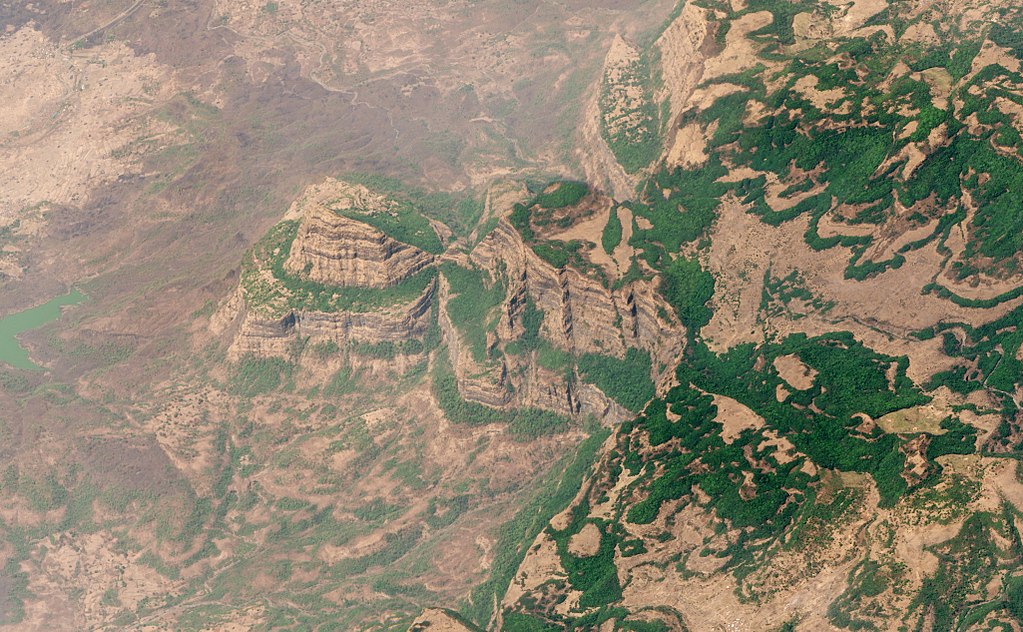
Satellite view of the Deccan Traps. Being one of the largest volcanic features on Earth, they consist of multiple layers of solidified flood basalt that cover an area of c. 500,000 km2.
Q. What about the linkage between variations in climate and human activities?
I do believe that present-day warming, and consequential climate change, are anthropogenic. As a matter of fact, there is a good correlation between temperature rise and carbon dioxide increase in the atmosphere. The large quantity of carbon dioxide and other greenhouse gases (such as methane, nitrous oxide, and fluorinated gases) in the atmosphere owe their origin to burning of the fossil fuels in industry, transport, agriculture, and buildings. Carbon dioxide, the principal greenhouse gas, takes flabbergasting one hundred years for its removal, and it has increased significantly over the past century to 419 ppm of the atmosphere (ca. in terms of sheer weight amounts to 40 billion tons). This is the highest concentration in the last four million years and twice the amount of pre-industrial time.
But climate change should not be viewed as an entirely warming phenomenon. Other human activities engaged in changing the landscape and cutting of forests, wastage and pollution of water and air, disrupting the ecosystem and habitat also pose serious threats to plant and animal life.
Q. The earth has been experiencing overwhelming natural disasters for the past few decades. How could modern technologies like GIS (Geographic Information Systems) and remote sensing help better understand natural disasters?
It is not correct to say that the natural disasters have been taking place over the last few decades. Major natural disasters have been occurring throughout human history, indeed geological history.
It is possible there has been an increase in the frequency of natural disasters over the past 50 years, but it can also be that because of faded memory and poor record-keeping we might be giving more importance to recent disasters which are fresh in the memory.
To illustrate, there were big floods in China in 1931 and 1887, and obviously, during that time we didn’t have the problem of present-day global warming. Those approximately killed 1-4 million and 1-2 million people, respectively. Going back further, China Shaanxi Earthquake in 1556 killed 0.83 million people and the Tangshan earthquake in 1976 killed 300,000 to 700,000 people.
The 2004 Sumatra tsunami in the Indian Ocean killed 200,000 people, but there was also the Italian Tsunami of 1908 that killed 123,000 people. As you can see, disasters have always been there, but whether their frequency increased in recent years is to be statistically confirmed.
I certainly agree that the use of GIS, Remote sensing, Early Warning Systems, and other technological tools and advances would be much helpful in the prediction and mitigation of natural disasters. In general, there is a fear that global warming and climate change are going to result in unpredictable weather, especially in superficial phenomena. To fight that, we need global collaboration because some of these events might be beyond the capacity of just one nation.
Q. Pakistan has been a frequent victim of earthquakes and other calamities. Why are we always underprepared in disaster management, when countries in similar geological states like Japan, are able to rebound so quickly?
It is a little too much to compare ourselves with Japan. Japan has a very old culture of science and technology and a very high level of education. Their financial resources and capabilities far exceed those of developing countries.
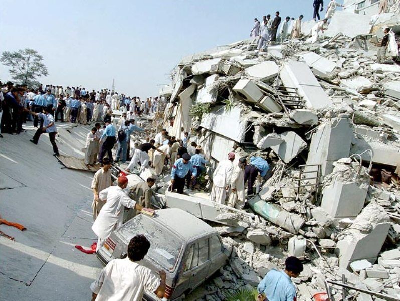
I agree that Pakistan is a seismically active zone and because of that natural disasters will keep on occurring. The 2005 Kashmir earthquake was very sudden. Even if we were prepared, we couldn’t have stopped the death of people from the jolt. And because earthquakes are not predictable, therefore you cannot evacuate towns in fear of a calamity that may not happen.
The 2005 earthquake in Pakistan was very sudden, killing around 100,000 people in the country and wounding many more. Credit: IRNA
Similarly, if you look at the 2010 flood, Pakistan couldn’t have done much regarding that because it was too sudden (at least in the northern part of the country) and too big. Within a short span of time, there was this huge quantity of rainwater thrown down in Swat and adjacent areas of Hazara and Dir which ultimately aggravated into big floods in the South.
I personally think that since the earthquake in Kashmir, Pakistan’s level of disaster preparedness and mitigation certainly has improved. The government has established an agency for the purpose of national disaster management and with the passage of time, it will continue improving.
Q. Even though Pakistan has big deposits of natural resources, why haven’t we been able to do efficient resource management.
There is a common misconception in Pakistan that we are blessed with an abundance of resources. We have to get rid of this notion. Undoubtedly, Pakistan is not poor in terms of natural resources, but to say that it has a lot, is very rich is an exaggerated statement. But having said that, the country has large quantities of building materials and marble; some industrial minerals, evaporites (rock salt and gypsum), a couple of big copper deposits, and semi-precious stones. Apart from copper, we don’t have large deposits of metallic minerals, but we do have some reasonable deposits of industrial minerals.
The biggest natural resource of Pakistan is water, but with the passage of time, Pakistan has become a water strained country. We have one of the most widespread irrigation systems in the world, but we are wasting too much water because of obsolete irrigation methods and extreme water pollution.
We have not been able to benefit because our policies have been unrealistic, and our implementation has been even worse. One example is the Reko Diq project. The unnecessary entanglements and wrongdoings cost Pakistan pay billions of dollars. This shows the flaws in our policies. All international agreements need to be reached on the basis of good scientific information and sound legal advice.
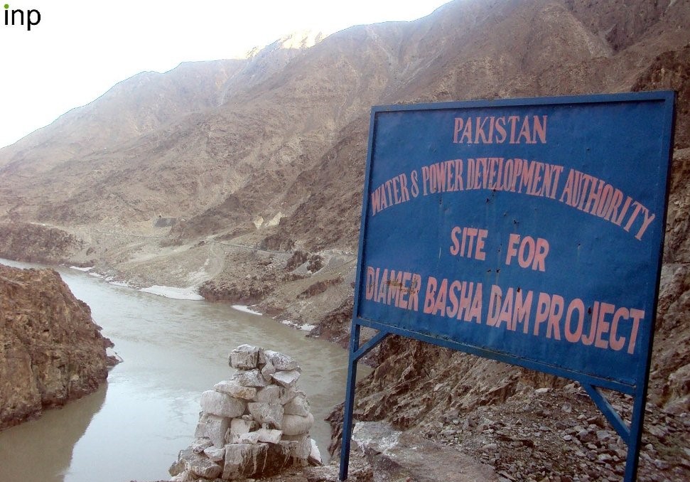
Q. From Kalabagh to Diamer Basha, dam construction has always been a subject of much controversy in Pakistan. Can you share why there is so much debate when we are in dire need of controlling our resources?
The only national controversy has been the Kalabagh dam. The construction of the Kalabagh dam was affected by 1) interprovincial differences, and 2) obsession of a particular lobby in its support. The proposal was opposed by the smaller provinces, despite perhaps insufficient scientific evidence; only fear. If it is technically a safe site despite active tectonics and a layer of salt under the dam site, then there is no reason why the Kalabagh dam project should not go ahead, firmly guaranteeing, of course, a fair supply of water to the provinces of KP, Balochistan, and particularly Sindh. In a country with the inconsistent implementation of decisions, this will not be an easy task! But we must also keep in mind that there are other sites upstream on the Indus and other rivers for water storage and power generation and these need to be quickly pursued.
As far as the Diamer Basha dam is concerned, there isn’t a serious seismological danger. About 40 to 50 kilometers from the site of the dam there is an active fault that runs along the western margin of Nanga Parbat. Because of mass movement (sliding) along the fault, the Indus River was dammed near Rakhiot (now Raikot) in the 1850s, resulting in a big lake. Later it burst and the flood wiped out a whole Sikh regiment stationed at Attock near Indus-Kabul confluence. I am sure the engineers and builders of the Basha dam would take precautionary measures to avoid disaster in case of large landslide in the area.
I conclude that we need to construct water storages, but not at the cost of affecting national unity. But equally important, we are wasting a lot of water and polluting the remaining, which needs even bigger attention.
A view of the DIamer-Basha Dam site at Chilas. Credit: INP
Q. There has been an establishment of Pak-China Earth sciences academic cooperation. What are your thoughts on that project?
Academic cooperation between Pakistan and China has been going on for quite some time and joint research is always good. The establishment of an earth sciences center in Islamabad will be impactful for three reasons. Firstly, it will improve our quality of education and research. Secondly, international researchers will have the opportunity to work in Pakistan with our scientists. This will be good for the promotion of science and global understanding through science diplomacy. Thirdly, the Center can play an important in the sustainability of CPEC. In the long run, a major goal of the CPEC is trade on land route between China and Pakistan.
Our land route, i.e., Karakoram Highway, passes through the tallest and rugged mountain ranges in the world (Himalaya, Karakoram, Hindu Kush, Kunlun) and is frequently blocked by mass movements, landslides and glacier surges, and glacial lake outbursts. It is essential to understand this region better through careful and detailed studies to ensure a smooth flow of trade along the KKH. As a matter of fact, this was also one of the primary reasons to establish this center.
Q. What contribution, do you think, your personal work has provided to the field?
Personally, I work for the love of discovering nature. As a human being, I believe I have a responsibility to understand the functioning of nature. The work we have done provides basic information about our hills and mountains. We have described rocks and minerals which are of interest to the economy and science of Pakistan. These include building materials (i.e., granites in Kohistan, Nagar Parkar, and Balochistan), chromites, gemstones, seismology, climate change, and natural hazards.
My research has not been primarily focused on minerals of economic importance, but it provided basic data for future activities on mineral exploration, engineering geology, etc. More importantly, our studies have contributed significantly to, and globally showcased, the crust building processes and geodynamics of northern Pakistan, Chagai-Raskoh arc, and Nagar Parkar. We (A.H. Kazmi & M. Q. Jan) also published a well-read seminal book on the “Geology and Tectonics of Pakistan” in 1997.
Q. How would you say the field of Geology/Earth Sciences has evolved with the advent of new technology over the years? And what is the status of geological research in Pakistan?
Geological sciences have indeed seen major advancements since the 1960s. First and foremost is the unifying theory of plate tectonics because of which we have started looking at the sectors of the earth from totally different and new perspectives. The earth sciences have become more multi-disciplinary and seen big advances in instrumentation. Thus, geology, in combination with space sciences and geophysics, have added much to surface mapping, subsurface structures, economic geology and petroleum exploration.
Pakistan also has progressed substantially in the earth sciences. At the time of independence, there were only a handful of geologists and few areas had been studied geologically. Today, there are over 20 departments and centers in the universities, and many organizations and companies which are involved in geological mapping, mineral exploration and exploitation, and oil and gas exploration. In this regard, the contributions of the Geological Survey of Pakistan (GSP) are highly admirable despite meager human, financial, and infrastructure resources. Some important earth sciences related finds include building material and decorative stones, industrial minerals, two big copper deposits, and oil and gas discoveries.
Geological research in Pakistan needs enhancement through induction of a larger number of well-qualified scientists and technical staff, well-equipped, properly maintained, and functional laboratories with sophisticated equipment, strengthening of the GSP, adequate support for fieldwork, and improvement of syllabi in the universities.
Q. What would be your advice to individuals interested in this field?
Success is fundamentally related to hard work, capacity building, a correct attitude, and working in close cooperation with colleagues. Ours is a field-dependent science and geologists should not lose focus on fieldwork. The world has become a global village and success requires passing through cut throat completion. Knowledge of developments in S&T and multi-national, multi-disciplinary, and multi-institutional collaboration is helpful for creativity and development of knowledge, sciences.
Scientists have discovered a gargantuan galactic wind emitted by a supermassive black hole some 13.1 billion years ago, the oldest one observed to date. This is a critical discovery as it can help shed ‘light’ on the development of galaxies in particular and for our modern universe in general.
Scientists from the National Astronomical Observatory of Japan (NAOJ) first identified a hundred galaxies having supermassive black holes in their center using NAOJs Subaru Telescope, a very powerful instrument with a wide observation capacity. They then used Atacama Large Millimeter/submillimeter Array (ALMA), which has more sensitivity, to study the gigantic galactic winds flowing outwards from the supermassive black holes.
Scientists believe that these physical interactions between black holes and galaxies have played a critical role in the development of our modern universe.
It is already known that the center of galaxies has supermassive black holes, billions of times huge than our sun. Scientists believe that these galactic winds, going outward from these supermassive black holes, have profound effects due to physical interactions and telltale the effects of supermassive black holes on the evolution of galaxies, something scientists term as coevolution ̵ evolution of black holes and galaxies together.
Scientists believe that these physical interactions between black holes and galaxies have played a critical role in the development of our modern universe. Supermassive black holes swallow up huge amounts of surrounding matter and stellar material. As the matter begins to swallow up into the black holes it starts swirling at high speeds due to the gravitational pulls of these gigantic monsters and starts to emit intense energy which can push the surrounding matter outwards. This is how the galactic winds are created.
Takuma Izumi, the lead author of the research paper and a researcher at the National Astronomical Observatory of Japan (NAOJ), says, “The question is when galactic winds came into existence in the universe? This is an important question because it is related to an important problem in astronomy: How did galaxies and supermassive black holes coevolve?”
The latest research was presented by the research group from NAOJ in the Astrophysical Journal Takuma Izumi et al. titled: “Subaru High-z Exploration of Low-Luminosity Quasars (SHELLQs). XIII. Large-scale Feedback and Star Formation in a Low-Luminosity Quasar at z = 7.07,”.
Through many hearts are breaking And many tears are shed So many houses broken Too many people dead God summoned his angels Sent them to the disaster zone To deliver their tiny perfect wings So they didn’t travel alone. ~Sally
Over the past decade, around three hundred natural disasters have occurred yearly worldwide, affecting millions and caused damages of billions. The displacement/ migration is evident after a disaster strikes an area, leaves millions homeless, and forces to move in temporary crowded shelters with little to no access to drinking water or food in a few days to rescue operation. Such living conditions often result in the spread of infectious diseases like Dengue, Tetanus, Malaria, and others. These natural disasters have also caused a substantial economic burden, from 2000 to 2009, they brought about approx. 891 billion dollars damage worldwide that include houses and mega infrastructure.
How many of us blame ourselves for this steady rise in natural disasters? None can ignore the fact that many of these calamities were man-made; they strike due to environmental degradation caused by global warming. Now slowly but at least not too late, mankind realizes that its greed has brought destruction to the earth’s natural systems.
When the desire for fast profits and growth beats the vision of sustainability, nature retaliates in the form of disaster. Our activities after the industrial revolution play a vital role in the fast pace of natural disasters worldwide. By supporting unsustainable developments, we caused deforestation that leads to more floods and land sliding. The sprawling cities with zero to no urban planning and increasing fossil fuel consumption impacted our environment and made changes in weather patterns.
With this edition, we aim to challenge media-driven stereotypes of disasters. More often than not, a disaster reported in Pakistan has a very short life; after a few photo sessions and press conferences by the officials, our media started playing political or showbiz beats.
Much of the rainforests are being clear-cut to make ways for cattle ranches. This led to deforestation and global warming, destroyed animal habitats, and also disrupted the water cycle. Without trees to absorb rainwater, floods and soil erosion is evident in many parts of the world where forests were mercilessly killed. Besides causing massive flooding, deforestation led to severe and prolonged periods of drought because forests are an essential part of the water cycle, bringing groundwater to the atmosphere, fewer trees means fewer rains, increasing the risk of drought.
Without trees to absorb rainwater, floods and soil erosion is evident in many parts of the world where forests were mercilessly killed.
The global warming caused by the industrial revolution has a profound impact on global weather patterns. The increase in atmospheric temperature resulted in speedy glaciers melting and bringing changes to oceans’ temperature. The coastal areas are under threat of high-intensity cyclones and storms from July to September. The constant rate of increase in ocean temperature will lead to more intense storms.
When a hurricane sweeps away entire houses, a flood seeps in through every corner of our lives, or a wildfire turns a dense forest into ashes, it leaves us speechless and miserable. But if we want to upgrade our reaction against natural disasters, we need to talk about them.
Pakistan geologically overlaps both with the Indian and Eurasian tectonic plates; two-thirds of Pakistan’s total area lies in fault zones that can cause tremors anytime. Pakistan is among the highly vulnerable countries due to climate change; massive floods, prolonged drought, cyclones, land sliding, glaciers melting, and earthquakes, we are destined to live with disasters.
Scientia Pakistan is launching its exclusive edition on Natural disasters to spread awareness about why natural disasters are evident and what we need to learn to stop their growing pace. We reached out to the acclaimed geologist of Pakistan, Dr. Qasim Jan, and Dr. Nayyer Alam Zaigham, to discover the geological changes in the region and how man-made activities are causing harm to the environment. For a more detailed understanding, there are stories of the most devastating natural disasters that hit different parts of the world during the last two decades. Moreover, we covered the role of remote sensing and GIS techniques for an effective disaster management policy and post-disaster rescue operation.
With this edition, we aim to challenge media-driven stereotypes of disasters. More often than not, a disaster reported in Pakistan has a very short life; after a few photo sessions and press conferences by the officials, our media starts playing political or showbiz beats. The media is ignorant of the fact that a minor calamity could cause far-reaching and long-lasting effects. The situation needs to be examined both by the governments and local communities. We want to enable the layperson to effectively play his role in a disastrous situation such as we faced in the Oct 2005 earthquake, 2010, and 2020’s massive flooding.
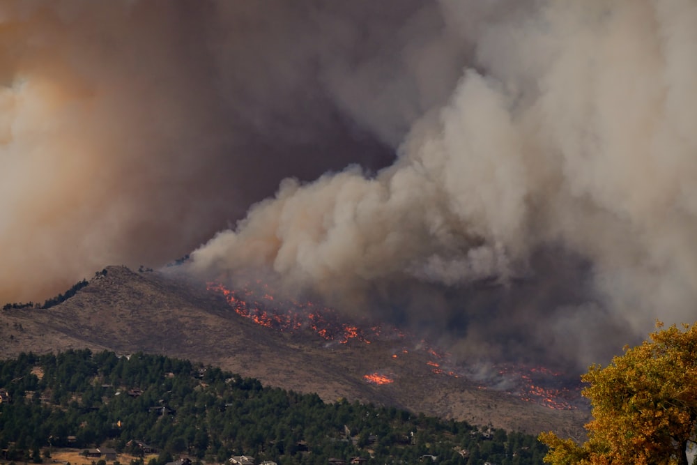
WildFire is not a new thing for Australia. The Australian landscape evolved because of fire. The survival of many plant species is depending on fire. There is a variety of species that adapted and even getting benefit from the fire in Australia. The Australian landscape was designed by fire in a way to prevent wildfire and also to provide resources. We know that the root cause of any natural disaster is somehow linked with global warming and overall climate change. Global warming is causing a slight rise in temperature, which leads to a decrease in rainfall in some areas of Australia. This phenomenon leads to an increase in the frequency, extent, and intensity of the wildfire in the last decades. These disturbed fire patterns increased their harmful effect on biodiversity.
According to Geoscience Australia, the leading natural reason behind these wildfires is lightning coupled with human and other biological activities. According to CSIRO, wildfire mostly breaks due to scorching weather and vegetation. But it is required to figure out the major cause of their ignition, whether lightning or accidental fire? When these factors combine with speedy winds, it results in a wildfire.
NSW RFS reported that lightning is the reason for the Gospels’ mountain fire which burnt 512000 hectares. The media reported Kangaroo island fire also started with lightning. It is concluded that in 2019-20 fires, most of the fires begin with lightning. The fires in Tasmania in December 2019 are because of deliberately lit fires results in 21000 to 35000 hectares burned.
Studies proposed that by 2050, the risk of wildfire can increase up to 25%. It is a need of an hour to understand their changing pattern, cause, and impact on biodiversity for better management of the disaster they caused.
According to CSIRO, wildfire mostly breaks due to scorching weather and vegetation.
Australia has faced extensive and continuous bushfires from June 2019 to Feb 2020. These wildfires are unexpectedly prolonged, and that’s why named Black Summer or season from hell. The outbreaks of 2019-20 adversely affected the NSW and Sydney. Overall, 2019 in Australia 2019 was recorded as driest and scorching. The FFDI (Forest Fire Danger Index), which calculates the intensity of danger caused by the wildfire in Australia, recorded the spring season in 2019 wildfire as the highest rate.
In 2019, about 15000 fires were reported in different areas, which collectively damage 19 million hectares of Australian land. This area is larger than the total burnt area of Amazon and California in recent fire events; an annual wildfire is widespread in Australia, especially the savannahs of northern tropical, last year damage the vegetation. An increase in temperature and extended drought conditions have worsened the condition at the start of November 2019.
In January 2020, heavy rainfall decreased the fires in some areas but unable to extinguish the fires completely. Drought, hotter temperatures combine with high winds increased the fires to a dangerous level again at the start of February 2020. This is followed by heavy rainfall in mid of the Feb 2020 results in the complete extinguishment of fires in NSE, but victoria was still facing the bushfire. All the fires completely stopped in March after nine months of prolonged bushfire season.
In 2019-20, wildfires affected millions of people living in these areas with 33 deaths and thousands of homes burned. The smoke from these prolonged fires causes air pollution in major cities, and even the smoke reaches over New Zealand. Hazardous air pollution causes about 400 deaths and hundreds of people hospitalized because of asthma, cardiovascular and respiratory issues. These fires released about 900 million tonnes of CO2 emissions. According to NASA, these fires produced a considerable amount of smoke, taking one complete circle of the Globe. In current times Sydney and Canberra are listed among the top 10 most polluted cities.
According to WWF estimation, about 3 billion native vertebrates are present in the 2019-20 bushfire areas, which include mammals, reptiles, birds, and frogs. These extended bushfires also affected endangered species, wildlife, ecological communities, and heritage Areas. Threatened species lost their required habitat because of these fires. The heritage sites like Gondwana InDuring 2019-20, many historical places like Greater Blue Mountain, and Old Great North Road were destroyed due to the wildfires. Many modeling and studies are carried out to explain the actual damage caused by 2019-20 fires on fauna and flora. However, much data is still an estimation from past fire events and requires detailed analysis and expert opinions.
Australia was able to come out of this emergency with the help of many Philanthropic and Governmental support. CDP (Center of Disaster Philanthropy) supports it with their global recovery funds; this helps donors meet the challenges presented by the global crises. These donations then transferred to various organizations working in the country to overcome the current emergency, just like the Australian Red Cross Society awarded $336,000 to help the human life affected by bushfires. It also includes three years of bushfire recovery programs.
FRRR (Foundation of Rural and Regional Renewal) awarded $500,000 to help at the community level and invest in community projects. This helps in the recovery of rural and remote areas of the country affected by bushfires.
WWF was also awarded $1.19 million for long-term recovery projects. This is actually for wildlife and restoration of the environment and natural habitat. The federal government of Australia announced in Jan 2020 the formation of the National Bushfire Recovery Agency. The government also initiates $A2 billion for recovery and helping the farmers, families, and businesses affected by bushfires.
The ongoing demand is the requirement of resources and funds for rebuilding communities and structure which resist the bushfires.


