The late Carl Sagan, author of Pale Blue Dot, often described the atmosphere as a “fragile skin, or a thin coat of varnish on a school globe”, a layer that protects what lies beneath it and, ultimately, the inhabitants of our world. To this day, the scientific consensus is that our planet is a remarkable exception in the vastness of the universe.
Earth is the only planet in our solar system with an atmosphere capable of sustaining and hosting life, contrary to other planets in our Solar System. Understanding Earth’s atmosphere and its variability has always been central to science for anticipating future risks, from climate change and natural disasters to habitability itself!
Delving into the science and experiments behind our atmosphere makes for a rewarding read, and it helps close a gap in public understanding that deserves attention. To bring these themes to life, we turned to an atmospheric scientist, and what follows is a series of exchanges on the questions that matter most.
Dr Joelle Buxmann is a Senior Scientist in Observations Research and Development at the Met Office, the UK’s national weather and climate service. She specialises in the remote sensing of aerosols and trace gases, including water vapour and ozone, and holds a PhD in Environmental Physics from Heidelberg University. Her day-to-day work involves measuring aerosols, clouds and volcanic ash through lidar networks and sun photometers, with applications spanning aviation, air quality and the wider environment.
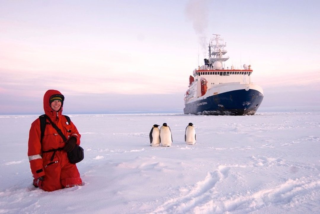
In addition, she advises student researchers and leads the WG-4 group at EARLICOST. In her early career, she spent a lot of time in fieldwork on the West Coast of Ireland, in remote locations in South America and Africa, and even traced gases with the Penguins in Antarctica.
Fouz: What made you decide to become a scientist?
Joelle: I’ve always been fascinated by the natural world around us, from a very young age. As a child, one of my favourite books was Our Blue Planet, which had a satellite image of Earth on it, and it captivated me. I loved both science and technology, and I used to play with an electricity kit where we could build relays, motors, and even a microscope. So as I grew up, I was drawn to physics because it seemed to combine all of my interests.
Later on, I learned about a project near the west coast of Ireland, and then I travelled to other remote places, including Africa and Antarctica. I personally think science is a very creative discipline, and I really love coming up with creative new ideas to understand and measure the scientific aspects behind our atmosphere. Here at the Met Office, we work on extreme weather events, and in recent years I have contributed to aviation safety and environmental monitoring, particularly with respect to volcanic ash.
Fouz: That’s really interesting, especially from an application perspective! Moving forward: how would you explain the atmosphere to someone with no scientific background?
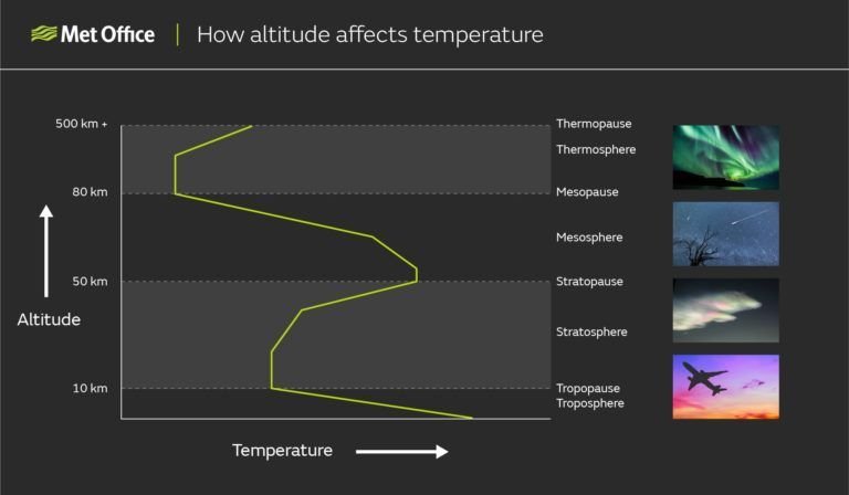
Joelle: For me, I think of it as a temperature roller coaster, as it decreases and increases, and this creates different layers in the atmosphere. First, the lowest layer is the “Troposphere”; most of the clouds, most of the weather events happen here, and most of the atmospheric mass is there. It goes from a few kilometres to 15- 18 kilometres, depending on the place you are measuring from.
The temperature decreases as you go higher in this layer. Here you will mainly find nitrogen, oxygen, CO2, water vapour and trace gases.
Above that is the “Stratosphere”, where we have the ozone, which protects us from harmful UV radiation. Here the temperature increases again. Then we have the “Mesosphere”, where it cools down once more, and then the “Thermosphere”, where the temperature rises again because of very high-energy UV absorption. This is also where the aurora happens, what we call the Northern and Southern Lights. Last comes the “Exosphere”, where the atmosphere becomes very thin.
Alongside these, we also have the “Ionosphere”, where molecules become ionised. It is used for radio communication and long-range lightning detection.
Fouz: Moving into the troposphere, scientists seem to talk about “aerosols” all the time. What exactly are aerosols, and why are they so important to scientists?
Joelle: Most people think of aerosols as something coming out of a spray bottle. In atmospheric terms, they are tiny particles which can also be coated with water, suspended in the air. You can find them everywhere around us, and they come from natural sources such as dust from the Sahara and other desert dust storms, sea salt, volcanic ash, which I mentioned earlier, and wildfire smoke. Due to human activity, we also emit a lot of pollution aerosols from industrial methods, cars and transport.
Critically, the pollution aerosols in particular affect human health and air quality. They can worsen respiratory illnesses and make asthma a lot worse, and they can even increase the risk of premature death, as suggested by many studies.
Interaction with the sunlight: They are also important because they interact directly with sunlight. Many aerosols cool the climate by reflecting sunlight back into space, so it never reaches the ground. Others absorb sunlight and can warm the atmosphere. They also interact with clouds: without aerosols we couldn’t have clouds, because even though there is plenty of moisture and humidity in the atmosphere, that moisture needs a surface to lock onto and condense. Only when aerosols are present can clouds form, this is how the nature works!
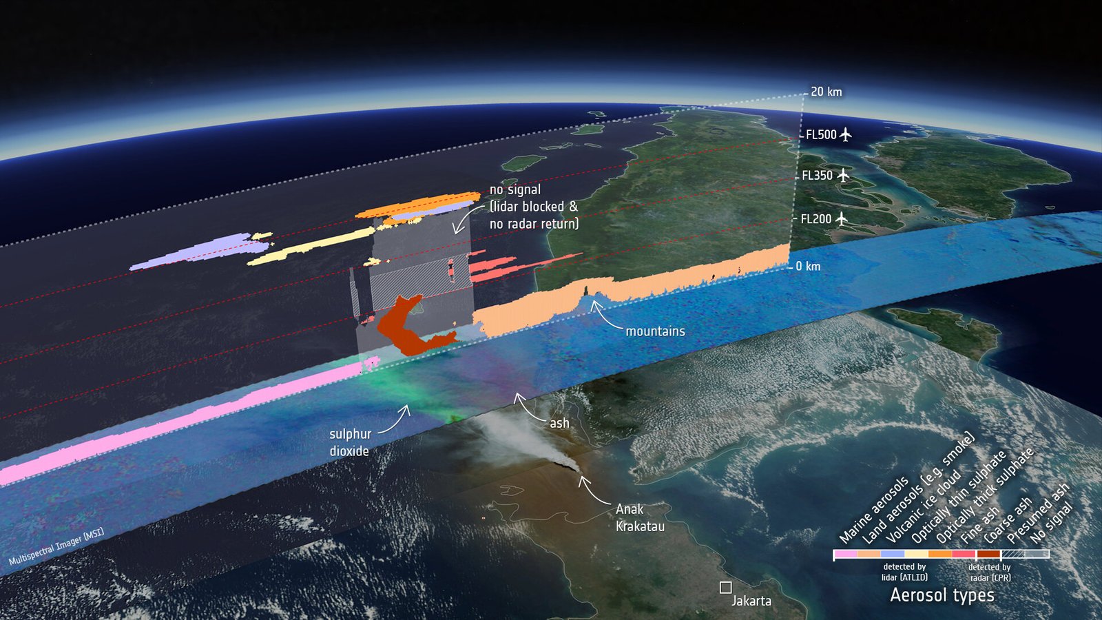
In the world of atmospheric science, this aerosol-cloud interaction is one of the major scientific uncertainties at the moment, and a lot of research is going into it. Understanding it is very important for knowing how our future climate will evolve! For me, as I referred to, volcanic ash is especially of concern. It is an aerosol type that affects aviation safety because, in high concentrations, it can clog up aircraft engines and make flying unsafe; in some cases, safety can be compromised, and monitoring its trajectory is very important to make decisions about where to fly safely.
Fouz: When it comes to detecting aerosols, what instruments do scientists use, and how do they observe, measure, and monitor them over time?
Joelle: For us, we mainly use Lidars! It works a bit like a radar, but it “Sends out pulses of laser light instead of radio waves”. When the light hits clouds or aerosol particles, some of it scatters back, and a telescope collects that backscattered light. By measuring how long the light takes to return, we can work out the exact height of the clouds and aerosols.
“What makes lidars so valuable is that they give us continuous, vertical profiles of the atmosphere.”
Then, we have a second instrument, the sun photometer, which uses sunlight rather than a laser. It can’t give us vertical profiles like a Lidar, but it measures light at different wavelengths, or colours, which tells us about the light’s interactions, indirectly telling us the size and other properties of the aerosols. When we combine sun photometers with lidars, we can further distinguish between aerosol types, such as volcanic ash, dust and smoke.
Third, we can use optical particle counters, which are used mainly at ground-level stations in cities. They measure aerosol concentrations, the particulate matter or PM values, at a single location, so they help us monitor the local ground density of particles, rather than observing the sky.
Fouz: Let’s turn to lidar observations. Scientists can study aerosols using both ground-based and space-based facilities. How do these approaches differ, whether we’re talking about individual observatories or networks? Using EarthCARE as an example of a space-based mission and TROPOS as a ground-based facility, what are the strengths and limitations of each approach?
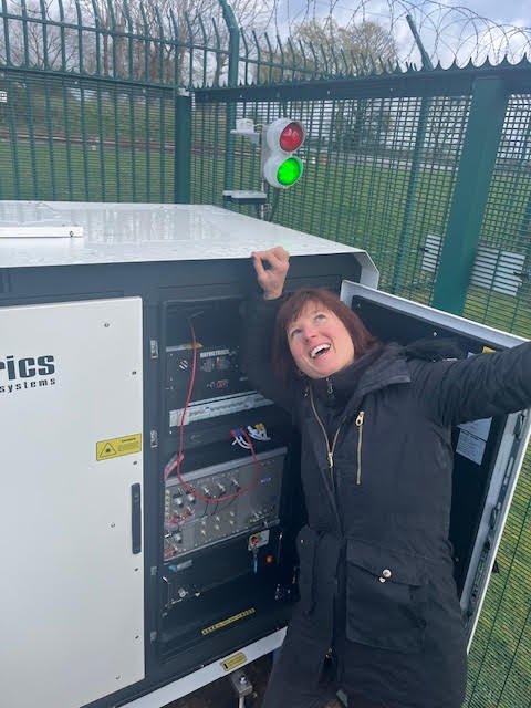
Joelle: In the UK (at the Met Office), we have a ground-based network of 10 high-power lidars, plus several low-power lidars called ceilometers, which are mainly used to detect clouds. Firstly, the ground-based instruments benefit from high temporal resolution. They sit at one point and give us very detailed local information about that location, and they can observe almost continuously. They can’t penetrate thick clouds completely, but when the sky is clear we get very good time resolution for that one location. They are also very good for instrument development, because you have them right there, and you can always get access: you can change some components easily and test how it affects the instrument and how you observe.
But as a negative aspect, they are very limited in geographical coverage. We have only 10 in the UK, which isn’t a small number, but isn’t a lot either, so we can only detect aerosols and clouds at 10 locations.
For space-based lidars, satellite lidars are actually quite similar! The one on EarthCARE (ATLID-atmospheric Lidar) and the ones we use are alike in wavelength and in what they can detect, but the satellite has global coverage with its spatial resolution gives us an advantage. It goes around the Earth, so it observes all the remote regions as well, such as over the oceans.
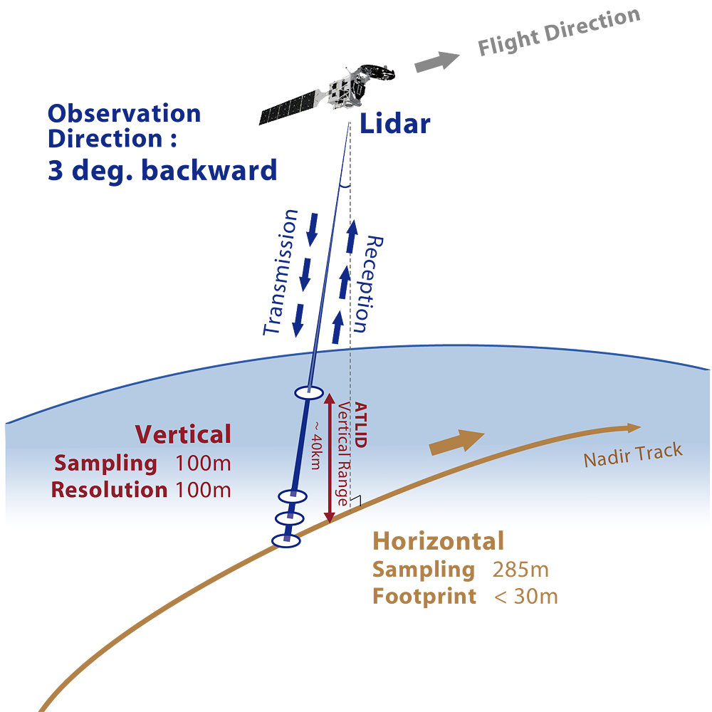
If we talk about EarthCARE, it flies in a sun-synchronous polar orbit at about 390 km, completing roughly 15 orbits a day. Its exact ground track repeats every 25 days, so the satellite builds up a global picture over time rather than watching any one place continuously. At the same time, its time resolution is quite limited: it revisits the UK only once or twice a day, depending on the satellite’s height and speed, so it is less continuous. But EarthCARE overpasses the close to same locations several times, and within about a week you get a whole picture, a near-global picture with some gaps.
So neither is better or worse. They complement each other. The satellite also looks from the top down to the cloud, while the ground-based lidar looks from the bottom up, so sometimes we can use them together to get a better picture for validation and a reduced-error overview of our area of interest.
From my perspective, ground-based measurements become more important in a way, because you need to validate what you see from space. You need to calibrate some of those instruments and make sure that the instrumentation up there is still working properly, and you can’t just go there and check it. There are algorithms and tests you can run, and some satellites have their own calibration, but I think ground truth will become more important if we have more satellites, not less.
Fouz: What role do aerosols have in Global Warming and our Climate Change projections?
Joelle: Greenhouse gases are the primary driver of our current warming, mainly from the burning of fossil fuels, which releases CO₂, and from methane.
But aerosols are important too. They can partially offset the warming by reflecting sunlight back into space, which has a cooling effect on our climate. Some aerosols can also contribute to warming, because they absorb sunlight.
And then, as I mentioned earlier, aerosols affect our clouds. Clouds are really interesting because they can either cool or warm the atmosphere, depending on their type and altitude. Very low clouds are more cooling, because they reflect sunlight back into space. But, for example, higher cirrus clouds, however, let a lot of the sunlight through and then re-emit the infrared radiation coming from the Earth into all directions including back to the surface. So they have a net warming effect. It really depends on this feedback mechanism. Aerosols also influence cloud properties: some can make clouds even brighter, so they reflect even more!
This cloud feedback affects our future warming. Clouds are relatively short-lived compared with greenhouse gases. We know you can have a very cloudy day and then no clouds the next, so there is quite a lot of variability. This aerosol-cloud interaction remains one of the largest uncertainties in our climate projections, so I think we really need better observations to understand how aerosols affect clouds and how they evolve over time, as they are among the most crucial uncertainties in climate.
Fouz: We collect many types of climate data, from greenhouse gases to water vapour. Where are the biggest gaps in our observations, and which parts of the atmosphere do we need to study more closely to improve climate projections?
Joelle: From my understanding, long-term observations are of incredible value, so continuity is very important for all climate-relevant observations; decades of data can help, with a 30- 40-year window (or more).
As I said, the interaction between clouds and aerosols is one of the biggest uncertainties, so measuring clouds and aerosols remains a priority, along with a better understanding of how they interact. A lidar is a very good instrument for this, because you get the vertical resolution and also a picture over time through the day.
I think more observations in polar regions and over the oceans would also help, especially profiles that include humidity and temperature, and we should combine satellite data with ground-based networks. The combination of these observations is really helpful, giving us a broader picture.
In addition, to get a whole picture that is relevant to climate, we need to work together and maintain international observing programmes. The collaboration is important, it gives us a geographical edge.
Our sun photometers, for example, are part of a global network run by NASA called AERONET (calibrated at PHOTONS in Lille), which goes back 30 years now, so we really have a climate-relevant time frame!
For lidars, there is EARLINET, a network that brings these instruments together and makes sure they are calibrated in the same way, so that different instruments can be compared. If one country measures one way and another country measures another way, and we make no attempt to compare them, that would make climate prediction very difficult.
So the collaboration between different countries, met services, and universities is really important for improving the datasets we need to evaluate our climate models…
Fouz: What does a typical day at the Met Office look like for you?
Joelle: My typical work week is a mix of working from home and going into the office. I work quite a lot from home, as you can see, since I’m in my home office at the moment, and I go into the office some days.
When I’m at home, I do lots of emails and administrative tasks. I also meet remotely with colleagues and international partners, such as yourself, and with students I supervise. For example, I’m involved in a COST Action called EARLICOST, which is where we both know each other from. It’s a European collaboration that brings scientists together to harmonise these measurements and make them more robust, and to look at new, innovative techniques that could improve our understanding of the atmosphere and climate change. At home I also do a bit of coding, and I advise engineers on site. If they run into trouble or have questions, I can help and support them from home.
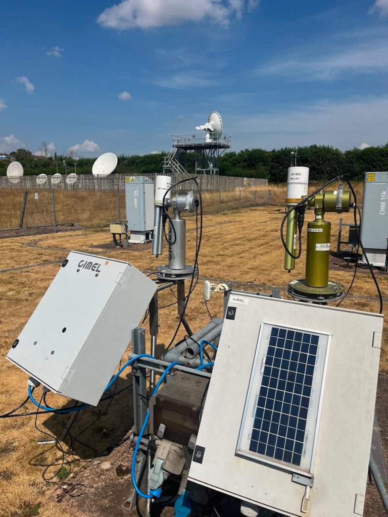
When I go into the office, I’m quite often in the laboratory or in our workshop. If an instrument is broken, I try to repair it. At the moment, for example, I have a few lasers in my office, and I’m looking into what’s wrong with them! When we get new instrumentation, I go and set it up for tests. We have a test site at the Met Office in Exeter, where I can set up new instruments, run them for a while and see how the data comes in, and I can maintain and repair them as well.
I work in research and development, so a big part of my job is supporting new observing capabilities, looking into new technologies and working out how we can bring them into our operational environment.
Fouz: That’s interesting! So, your work goes beyond observations and data analysis to include developing and working with engineers on the instrumentation itself?
Joelle: Yes, I work very closely with the engineers. I’m quite often the one who tests something new and comes up with a new way of doing it, and then the engineers help me turn it into a deployable piece of kit, set up properly with all the electronics in place. I can do it myself, but the engineers make it more robust, and they help me produce it, say, ten times and then set it up all over the country.
Fouz: What have been some of the biggest challenges you’ve faced in your scientific career, both personally and in the broader field?
Joelle: Well, if I think about this, the hardest scientific challenge for me was during my PhD and post-doc research.
I was looking into halogen oxides, which are halogens that affect ozone. They can destroy it. Many people might have heard about this in connection with the ozone layer, where halogens such as chlorine and fluorine were destroying ozone in the polar regions. I was trying to detect them near the surface, where they are present in very, very small amounts.
The scale is called parts per trillion, so basically a few of these molecules per trillion air molecules. A trillion is a 1 with 12 zeros, and it’s extremely difficult to detect them.
We had highly sensitive instrumentation, some of which I built myself, together with my colleagues, and I went out on field campaigns to South Africa, Antarctica and Ireland to try to detect them. In many of those places, I couldn’t. They remained below the detection limit. They had been detected there before, but under different circumstances, and our instruments worked well. They were highly sensitive, but the atmosphere is so variable, and you cannot control the environmental conditions.
That was an interesting learning curve for me: nature always surprises us, and even negative results are still valuable! That’s what I learned from it. You have to be persistent and patient and not be put off when something doesn’t work out the way you thought it would, because uncertainty is just part of science, and nature is interesting like this.
Right now, I’m moving more into using machine learning techniques on my data. I’m using them to identify different aerosol types from sun photometer data, such as dust, biomass burning and pollution, and now I’m trying to integrate volcanic ash. That’s a bit of a challenge at the moment, because ash occurs only rarely in northern regions. Luckily, we have this global network, machine learning is really helpful, and I have great students and colleagues working with me on this.
I think this is one of the most important problems for me at the moment: to identify the aerosol type. If you know the aerosol types and the clouds that occur with them, then in my experience that will also advance our understanding of cloud-aerosol interaction, which is one of the biggest uncertainties.
What I’ve learned from my campaigns, and it holds today, is that scientific progress comes from being persistent and embracing uncertainty, and from being willing to learn from my results. If they don’t match what I expect, I have to re-evaluate my theory and think about a different solution to the problem.
Fouz: Finally, let’s talk about AI. While it’s improving efficiency in many areas of our lives, it also raises concerns, including the growing energy demands of data centres, both on Earth and potentially in space. As a scientist, what’s your overall perspective on AI? What benefits and challenges do you see, particularly in your field?
Joelle: Yes, I think there are really great opportunities in AI. Since last year, I’ve been using it more and more, I have to say, to draft or to help me refine my writing, for example. It’s very good for that sort of thing because, obviously, the major AI we’re using is these large language models, which are very good with words, to put it that way.
There are huge opportunities in medical advances as well. We’ve seen recently that AI has come up with a new type of virus, which can also be dangerous. Obviously, there’s a lot of fearmongering and a lot of dangers discussed in the press, and I think we have to be careful.
But one danger I’m thinking about is that even if it’s not artificial general intelligence that’s way more intelligent than all humans, that’s the big fear, if it’s reasonably intelligent and has access to resources, knowledge and some code, it can now also write a lot of programming code. It can really jeopardise systems and hack into them. One danger lies in how people choose to use AI, especially as increasingly powerful capabilities become widely available. We need regulations to keep it in a good, limited and ethical space so it can’t cause too much harm. I’m not the right person to give advice on exactly how we do this. I just know that we really have to bring this into the public space and discuss how we can use it safely, get the benefits, because it is beneficial and useful, but also use it in a way that “We don’t lose our own thinking”.
In science, we still need our observations. We need our models to validate what AI is outputting because it’s known to come up with new realities, with new ideas that don’t actually agree with science or the facts. So we have to prove what it’s giving us and validate the results.
I think our own thinking becomes more important, but AI can certainly be used to do boring tasks, like filling out spreadsheets and expand our capabilities! You still have to check it, but it’s an incredibly useful technique, for sure.
In terms of environmental impact, obviously, that’s another thing we have to be aware of. It’s fun to use it once in a while to come up with a funny picture. I don’t know, turn myself into a cat! But you need to be aware that it uses resources, electricity and water. With bigger data centres, we need bigger pieces of land, and we have to think about this, especially in terms of climate change. We need to be aware of the impact and use AI responsibly.
Also Read: Genetics in the Spotlight: Perspectives from a Scientist and Communicator Dr. Alex Dainis